Subject: Holy Land
Period: 1604 (circa)
Publication:
Color: Hand Color
Size:
19.3 x 11.5 inches
49 x 29.2 cm
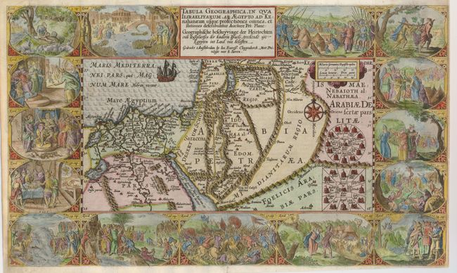
This extremely decorative Bible map illustrates the region surrounding the Dead Sea through the Nile Delta and depicts the wanderings of the Children of Israel. Beautifully engraved panels at the top and bottom include vignettes of important events of Exodus, Deuteronomy and Numbers. Inset within the map are two depictions of the Tribes surrounding the Tabernacle in the desert. This is the first state published by Cloppenburg with the signature of the engraver P bast F (Peiter Base Fecit) in the vignette of Exodus 12 at left.
References: Laor #566; Poortman & Augusteijn #75.
Condition: B
The impression in the map is a bit stronger than that of the vignettes. There is professional and very skillful paper restoration along the left side, with a bit of the corner replaced in facsimile. Part of the top and the left side margins have been replaced, leaving the right side margin still very narrow (1/8").