Subject: Western Hemisphere , South America
Period: 1711 (circa)
Publication:
Color: Hand Color
Size:
19.3 x 26 inches
49 x 66 cm
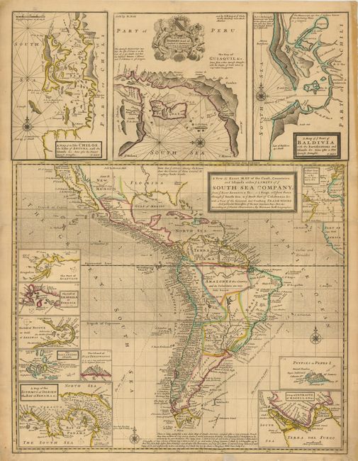
This is a fascinating and uncommon map of South America that includes the southern portion of North America with the island of California and Central America. The sheet also has twelve smaller inset maps, including Isle Chiloe, Acapulco, the Galapagos Islands, the Isthmus of Darien, Straits of Magellan, Juan Fernando, the Gulf of Nicoya, the Gulf of Fonseca, Port Baldivia (Valdivia), the sea route from England to the Orinoco, the Bay of Guayaquil, and, interestingly, an inset of the phantom Pepys Island. Pepys Island was named for Samuel Pepys by Ambrose Cowley in 1684, who placed it a couple hundred miles north of the Falkland Islands. Many expeditions attempted to locate the island, and it is assumed it was a misplaced member of the Falkland Islands. The top three insets are printed separately and joined to the main map, indicating this is the second state per McLaughlin. The map is filled with indications of currents, trade winds and compass roses. The decorative cartouche in the map of Guayaquil contains a dedication to Robert, Earl of Oxford.
References: McLaughlin #181.
Condition: B
On a thick sheet with a fine impression and lovely coloring. A short crack at left along horizontal centerfold, a couple marginal tears at bottom with small portion missing filled in with laid-in tissue on verso. A few more small marginal splits have tissue support on verso. Despite these few flaws the map shows very well.