Subject: Russia
Period: 1613 (published)
Publication: Petit Voyages (Indiae Orientalis) Part X
Color: Black & White
Size:
13 x 5 inches
33 x 12.7 cm
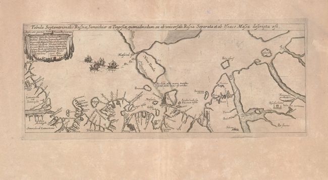
This exceptional little map is De Bry's version of one of the most important maps of northern Russia. It is based on the map of Isaac Massa and Hessel Gerritsz from a year earlier, which is now extremely rare. Massa traveled in Russia from 1601 to 1609 and returned with a rich collection of geographical and cartographic material, much of which the Russian government had tried to keep secret. The map represents the northern coastline from the Onega Peninsula to the Rivers Ob and Pyasina. The landmasses of Novaya Zemlya and Vaygach are shown with a wide sea passage between the two (with a note stating that such a passage is only possible in the summer months). The title runs across the top of the map and a key is enclosed in a cartouche at left. A small fleet of ships and a group of seals are depicted off the coast of Novaya Zemlya. This map provided the cartographic foundation for maps of the region throughout the seventeenth century.
References: Garratt, Map Collector #9, p. 11.
Condition: B+
The paper is lightly toned and the centerfold has been reinforced with tissue on verso.