Subject: World
Period: 1675 (circa)
Publication:
Color: Hand Color
Size:
22.3 x 18.8 inches
56.6 x 47.8 cm
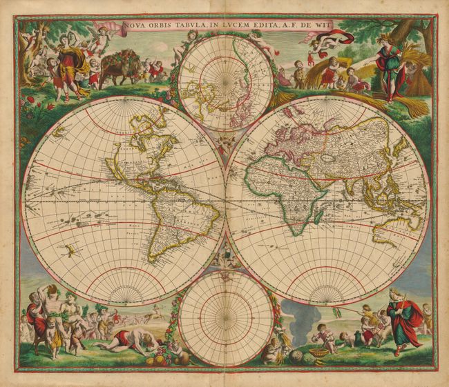
This is one of the most attractive double-hemispherical world maps of the late seventeenth century. The corners are filled with images of the seasons, the zodiac, and the elements, all combined within four well-composed vignettes. At top left is a personification of Spring, who also represents Virgo, with the element of Air billowing her robes. The bull of Taurus and the ram of Aries are shown to the right. The top right vignette represents Fall, with the shore in the background including the element Water. A putti holds a crab representing Cancer, and the lion of Leo is held by another. The twins of Gemini flank the inset of the North pole at top. The lower left scene presents summer and Earth with a wine-imbibing Bacchus held aloft by putti, while one of his devotees is dramatically ill in the foreground. The signs for Scorpio and Libra are held by two followers, while Sagittarius gallops in the background. Winter holds court in the final vignette, with the element of Fire shown to the left. Aquarius is represented by a child pouring water, while another holds a fishing pole with the double fish of Pisces, and a goat representing Capricorn is pulled by another.
Though typically assigned a circa 1670 date, it may well have been engraved in the 1660s, based on the Great Lakes and Hudson Bay cartography. The Great Lakes are shown as one large semi-circle with an open end, and the inset of the North Pole shows Hudson Bay with two southern bays. The island of California is shown on the Briggs model with a flat northern coast, with a portion of Anian in the Pacific Northwest. South America has the mythical L. Parime astride the Equator, with the imaginary golden city of Manoa named on its shores. Asia displays a Japan with an oversized Iedso (Hokkaido) shown on the map of the Western Hemisphere. A partial coastline for Australia is shown attached to New Guinea, and both New Zealand and Tasmania are indicated by only one stretch of coastline. The inset of the South Pole is nearly blank save for the very tip of South America and Tierra del Fuego. This is the second state with the more decorative border and putti inserted between the cusps of the map.
References: Shirley #451.
Condition: B+
Fine impression and superb original color. There is some toning along the fold, which has been reinforced with old paper on verso, closing a separation at bottom.