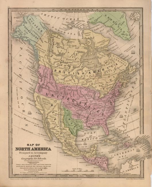
Subject: North America
Period: 1839 (dated)
Publication: Smith's Geography for Schools
Color: Hand Color
Size:
8.3 x 10.4 inches
21.1 x 26.4 cm
The Republic of Texas was a sovereign state in North America from 1836 to 1845. It was formed as a break-away republic from Mexico by the Texas Revolution. The nation claimed a large region that included all of the present state of Texas together with part of the former Mexican region of New Mexico (parts of present-day New Mexico, Oklahoma, Kansas, Colorado, and Wyoming). The eastern boundary with the United States was defined by the Adams-Onís Treaty between the United States and Spain, in 1819. Its southern and western-most boundary with Mexico was under dispute throughout the existence of the republic, with Texas claiming that the boundary was the Rio Grande, and Mexico claiming the Nueces River as the boundary.
An early example of this copper engraved map that shows the United States with a population of 17 million people. The Independent Republic of Texas with Austin as its capital is prominently featured. The entire western region is mostly unsettled with only a few place names including St. Francisco, Monterrey, St. Diego and Albuquerque. In the vicinity of Santa Barbara is St. Louis, a name we've not see on any other map. Alaska is a large blank area labeled Russian Possessions with the notation Unexplored Region and Canada is labeled New Britain as well as British America. In the Northwest, the U.S. extends well up into Canada to the 55th parallel, an early indication of the tensions between the United States and Britain in their claims in the region. Mexico controls the entire Southwest and California up to the 42nd parallel. The Great Basin area is shown as the huge Great Sandy Plains, and the Great Salt Lake is too far to the east and simply called Salt L. The map extends to include Greenland, Central America and the Caribbean.
References:
Condition: A
Original color on a sheet with faint marginal toning.