Subject: Southwestern United States
Period: 1860 (published)
Publication: HR Doc. No. 42, 36th Congress, 1st Session
Color: Black & White
Size:
49 x 7 inches
124.5 x 17.8 cm
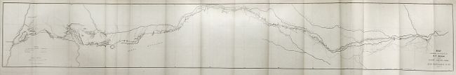
Edward F. Beale [1822-1893] had quite a career in the West including Indian Agent, surveyor and camel driver. His most lasting contribution was as a road builder. This map resulted from the survey of a road across present-day Oklahoma, Texas and New Mexico. His route roughly follows the Canadian River and closely parallels or is identical to that of Lt. Whipple just a few years earlier. A dotted line indicates where the routes diverge. Beale's 62 camp sites are numbered by day. The map is complete with its original 91-page report, "Wagon Road - Fort Smith to Colorado River" is from John B. Floyd, Secretary of War, to the Hon. Wm. Pennington, the Speaker of the House of Representatives. It is a detailed, day-by-day account of Beale's explorations. A scarce set in remarkable condition.
References:
Condition: A+
Map, folding as issued and still in the report. The disbound report is clean and bright.