Subject: United States - Mid-Atlantic and Midwest
Period: 1794 (dated)
Publication: Historical, Geographical ...View of the United States
Color: Black & White
Size:
18.5 x 14.8 inches
47 x 37.6 cm
By the time of the Revolutionary War, the practice of awarding bounty land as an inducement for enlisting in the military had been a long-standing practice in colonial North America. Besides imperial bounty land grants, both colonial and municipal governments routinely compensated participants in and victims of military conflicts with land. Land was a commodity in generous supply, and governments seized upon its availability for accomplishing their goals.
Following this tradition, the Revolutionary governments used bounty land grants in their struggle for independence from Great Britain. They generally offered free lands in exchange for military service, provided they were victorious in their struggle. Thus, bounty lands were an effective technique for enrolling support for the war and encouraging re-enlistments. Generally the bounty lands were located on the western frontier, which provided another benefit to the government. Populating the frontier with citizens skilled in defense offered the best prospect in enticing other settlers to join them, thus eventually increasing the tax rolls.
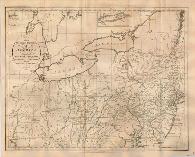
This detailed map extends from New York through Delaware and west to Lake Huron, Great Traverse Bay, Ft. Miami and Ft. Washington. The area west of Virginia includes several Bounty Land Grants: Seven Ranges, Army Lands, Ohio Company, Donation Lands from the Commonwealth of Virginia, and Colonel Simmes Grant. It also shows Indiana in what is now West Virginia. This region was originally granted to a Philadelphia trading company by the Iroquois Confederacy in 1768. Then in 1776 it was sold to the Indiana Land Company, but was also claimed by the State of Virginia as a part of her original charter. The resulting battle between the private land company and Virginia resulted in the Eleventh Amendment to the U.S. Constitution and is one of the most interesting chapters in the history of the young United States. The map also names a host of early settlements including Hurricane Toms, Morgans Town, Lick Town, Kill Buck Town, Salt Lick Town, Wills Town, New Comers Town, and Beavers Town. It also locates Indian villages, forts, and mines.
References:
Condition: B
A nice impression on a sheet with folds as issued. There is some offsetting and a few fold separations, repaired on the verso with archival tape.