Subject: North America
Period: 1693 (circa)
Publication: A Geographical Description of the Four Parts of the World
Color: Hand Color
Size:
21.5 x 15 inches
54.6 x 38.1 cm
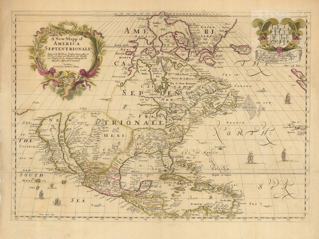
This was the first English map to portray all five Great Lakes based on the Sanson model. Newfoundland is improved with the depiction of the Avalon peninsula, and the mid-Atlantic coastline is also considerably updated. California is presented as an island, also on the Sanson model. The region labeled Florida takes in most of the Mississippi River valley and stretches from R. of Palmas (in present day Mexico) to the Florida peninsula, which is depicted with a central mountain range. The whole map is covered with depictions of indigenous animals, and ships and sea monsters decorate the oceans.
Richard Blome was a prolific publisher of cartographic and heraldic material who utilized the subscription method to finance his ventures. By paying in advance a subscriber was rewarded with a map being dedicated in his honor. Blome, took the practice to the extreme by selling the sponsorships yet again for subsequent editions. The original dedication in the upper right corner of this map has been replaced by a sheet pasted over that bears the arms and dedication to "the Worshipfull Jeffrey Jeffreys of the Priory in Brecknokshire and the City of London." This is the fifth state of the plate according to Burden, and a variant of state 2 according to McLaughlin.
References: Burden #397; Tooley (America) p.119; McLaughlin #42.
Condition: A
Original color that is slightly faded. Issued folding, now pressed with a couple of minor repairs on fold intersections.