Subject: Ireland
Period: 1606 (published)
Publication: Theatrum Orbis Terrarum
Color: Hand Color
Size:
22.5 x 17.1 inches
57.2 x 43.4 cm
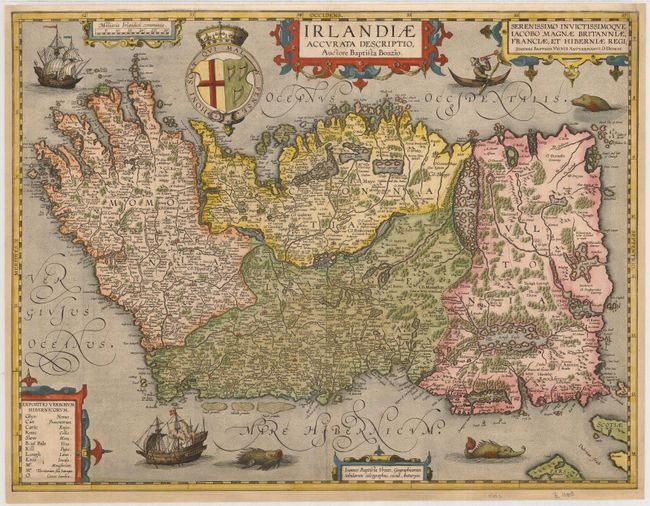
This beautiful map of Ireland with north oriented to the right is based on the large 1599 map by Baptista Boazio. It is divided into the four provinces of Ulster, Connaught, Leinster and Munster with counties delineated by dotted line. It is filled with pictorial depictions of the forests and topography and the location of cities, towns and major landowners. A table to the left deciphers the Irish names relating to geographical features and residents, noting that the presence of O before a name indicates Caput familiae, or the head of the family, and Mc before a name indicates a Territorium fillii Satrapae, a region dominated by one related family. The sea is teeming with sea monsters and a pair of elegantly engraved ships, one of them aflame. A man in a curragh waving a trident is shown in the upper right near the dedication cartouche, and three other elaborate strapwork cartouches further adorn the map.
This map was among the additions made by Vrients when he took over publication of the Theatrum after Ortelius' death. It was published in relatively few editions and is very uncommon, especially in the first state, which contains the dedication to James I. This example was published in the even less common English edition, with related text on verso.
References: Law pp. 6-9; Potter pp. 96-97; Van den Broecke #23.1a.
Condition: B+
This plate was always too large for the atlas in which it was bound, so most extant examples have margin defects. The margins on three sides of this map have been professionally and skillfully extended with the leaf-casting method. The bottom border and part of the lower portion of the left border have been reinstated in excellent facsimile. Were it not for the remargining, the map would be graded A+, as it is a beautiful impression with fine old color.