Subject: Texas
Period: 1843 (dated)
Publication: The London Atlas of Universal Geography
Color: Hand Color
Size:
19.8 x 24 inches
50.3 x 61 cm
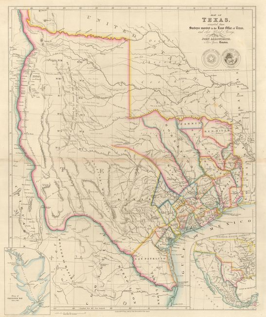
This is the third issue of this scarce and important map of the Republic of Texas. It is likely the first to show the full extent of Texas' claim to the upper Rio Grande valley, an area that would remain a part of Texas until the Compromise of 1850. It is also one of the earliest maps to contain information from the General Land Office of Texas with the delineation of pioneer county development and land grants, including those for Castro, Kennedy, Pierson, Fisher and Bourgeois d'Orvanne. The map provides an accurate depiction of boundaries, river systems, Indian tribes, and major roads. The many details include the Waggon Rd. to Santa Fe, the Presidio Road, the Commanche Road, and road to the Red River, which included along its way a Sick Camp and the grave of General Leavenworth. The arid western region purportedly explored by Le Grand in 1833 notes an expansive area as being naturally fertile well wooded & with a fair proportion of water; a erroneous notation that appears in this region on maps throughout much of the nineteenth century. This region is also embellished with notations designed to promote immigration, such as valuable land, rich land, beautiful prairie, and delightful country. At bottom are two insets; a plan of Galveston Bay and a map of North America showing the relationship of Texas to Mexico and the United States. Only the second and third states include the inset of Galveston Bay, and show the full extent of republic's claim to the headwaters of the Rio Grande. Below the seals of the Republic of Texas and the Texas General Land Office is the notation, Recognized as an Independent State by Great Britain 16th Novr. 1840. At the lower neatline is the imprint London, Pubd. 8th June, 1843. by John Arrowsmith, 10 Soho Square.
References: MCC-69 (Tooley) #263; cf Martin & Martin #32; cf Wheat (TMW) #451.
Condition: A
Lovely impression and original outline color printed on a sturdy sheet. There is some faint toning on the centerfold, and a small spot of foxing, otherwise it is pristine.