Subject: United States
Period: 1846 (circa)
Publication:
Color: Hand Color
Size:
14 x 9.2 inches
35.6 x 23.4 cm
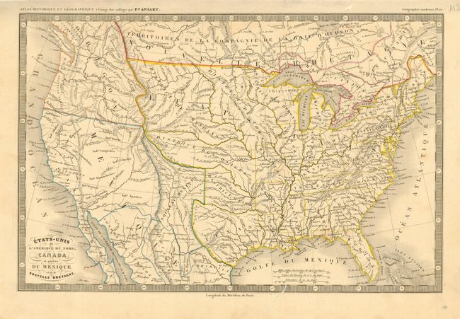
The United States and Great Britain established in 1818 joint claim over the Oregon Territory - the region north of Spanish controlled Upper California up to the southern boundary of Russia's Alaska Territory at North latitude 54°40'. By the late 1830's this arrangement was beginning to fall apart.
In the 1840's the expansionist Democrats, including their 1844 presidential candidate, James Polk, claimed the entire region for the United States. Their expansionist desires were expressed by Polk's famous campaign slogan, "Fifty-four Forty or Fight!" The slogan also became a rally cry for Americans desiring to settle the territory. Following Polk's election, the dispute was resolved by the 1846 Treaty of Oregon, which struck a compromise that fixed the U.S./Canadian boundary at 49º North.
An uncommon map showing fascinating transitional state and territorial boundaries. Oregon Territory reaches way up into British Columbia, but it is shown by color belonging neither to the United States nor to Canada. Texas is a part of the United States, but it is shown in a smaller configuration without its panhandle reminiscent of its early days as a republic. Above Texas, all the divisions are based on native tribes. The map is enclosed in a keyboard style border.
References:
Condition: B
Original outline color. A few wormholes in the map, mostly confined to the border.