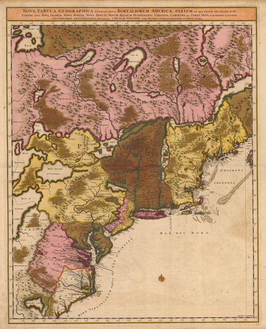
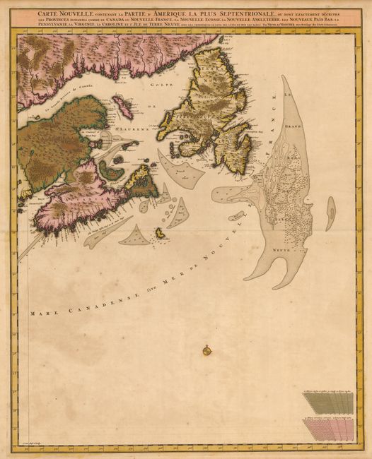
Subject: Colonial United States & Canada
Period: 1699 (circa)
Publication:
Color: Hand Color
Size:
18.6 x 23.5 inches
47.2 x 59.7 cm
First state of this stunning map on two separate sheets, covering the Atlantic coast from the Carolinas to Newfoundland, and including the Grand Bank to the Great Lakes, depicting Lake Ontario and parts of Lakes Huron and Erie with a portion of Hudson Bay at the top. The map does not appear to be based on any one source, but draws from the Coronelli/Nolin map of 1689 as well as Dutch and English sources. It displays the divisions between the French and British colonies, including New York, New Jersey, Pennsylvania, Virginia, Maryland and Carolina with meticulously engraved towns and topography. It depicts the colonial settlements along the seaboard and the rivers, while in the interior a number of native nations are shown. The southern portion of the map shows the May River leading from the fictitious Apalache Lac , and the sea off the coast is called The Sea of Virginy. Both sheets have compass roses and soundings noted along the coasts. One map contains the French title and the other the Latin title.
References: Burden (II) #731; McCorkle #689.8; Kershaw #319.
Condition: B
Dark impression with original color and a couple spots of foxing. Both sheets have been professionally backed with Japanese tissue to stabilize the oxidation of the green color. There is a small area of loss on Nova Scotia with paper replaced.