Subject: Ireland
Period: 1610 (dated)
Publication: Theatre of the Empire of Great Britain
Color: Hand Color
Size:
20 x 15 inches
50.8 x 38.1 cm
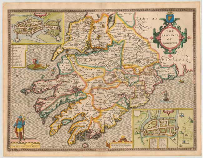
A fine, decorative map of the Irish province of Munster, located in the southwest of the island. Munster is the largest of the four provinces, with the counties of Limerick, Waterford, Cork, Clare and more. The map is inset with plans of the towns of Cork and Limerick, with keys to the important buildings. Many places are named including Tipperary, Bantry Bay and the Dingle Peninsula. The sea is engraved a beautiful moiré pattern, decorated with ships and sea monsters, including one being ridden by an Irish bard playing a harp. The Shannon River, which is nearby , was said to be formed by Sionan as she was swept out to sea after eating a forbidden Salmon of Knowledge. The map is decorated with three cartouches; one for the title that is surmounted with the crest of Ireland, the small one referring to the maker, and the last for the scale of miles, topped with a man holding calipers. From an early edition with the imprint of John Sudbury and George Humble. A desirable example beautifully engraved by Jodocus Hondius and printed on the higher quality and thicker paper. Related English text on verso.
References:
Condition: A
Nice impression and color. Bottom centerfold split, just into border. Couple of marginal stains and chips, else fine.