Subject: United States
Period: 1839 (dated)
Publication: Smith's Geography for Schools
Color: Hand Color
Size:
17.4 x 10.3 inches
44.2 x 26.2 cm
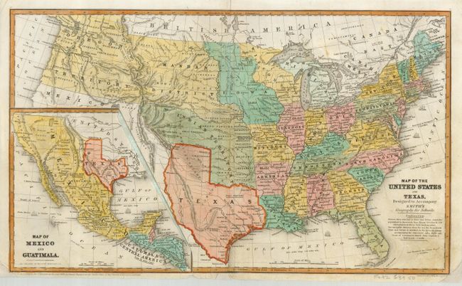
This is a great school atlas map with full original hand coloring to delineate the early territorial borders in the West. Features the Independent Republic of Texas with Austin shown as the capital by a large star. The huge territory of Oregon probably extends to the Continental Divide, but the coloring extends it through Mandan District to Iowa. It also extends north well into Canada. The huge Indian Territory lays north of Texas and extends to the Mandan District, which in turn goes to the border with Canada. Iowa is in a rare configuration that has it stretching from Missouri to the Canadian border and bounded east and west by the Mississippi and Missouri Rivers. Each state/territory is annotated with the population. The large inset at lower left is a detailed "Map of Mexico and Guatemala" and also shows the Republic of Texas. The inset completely covers the Spanish holdings on the main map. Published for Smith by Daniel Burgess.
References:
Condition: B
A little foxing or toning in a few places. Some marginal flaws professionally repaired and map backed with Japanese tissue.