Subject: Canada and North Atlantic
Period: 1750 (circa)
Publication: Reise nach Hudsons Merrbusen
Color: Black & White
Size:
17.5 x 6.8 inches
44.5 x 17.3 cm
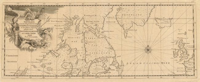
A lovely, simple chart adorned with a compass rose and a decorative cartouche. This map is focused on Hudson Bay, the Great Lakes, Labrador, Davis Strait, Greenland and Iceland across to the British Isles. The cartography shows a rather outdated configuration for the Great Lakes, and there is an odd bit of California at the far west of the map. Henry Ellis was an English explorer who set out in 1746 to discover a Northwest Passage from Hudson Bay - this map shows the tracks of his exploration outward and his return. His unsuccessful search ended the explorations for a passage via Hudson Bay. Ellis was also the second governor of colonial Georgia, after which he governed Nova Scotia. He was very influential in the early colonial government, assisting with writing of British policy.
Ellis' book, Voyage to Hudson's Bay, by the "Dobbs Gallery" and "California", In the Years 1746 and 1747, For Discovering a North West Passage; With an Accurate Survey of the Coast, and a Short Natural History of the Country proved quite popular, especially due to its early descriptions of the Eskimos. It was reprinted in Dutch, German and French editions. This map is from a German edition. It is an unknown state of the map, not noted in Kershaw. Engraved by Pufchel.
References: cf Kershaw #439.
Condition: A
Very crisp engraving. Hinge remnants on verso, small tear at upper right corner margin, just short of neatline.