Subject: North America
Period: 1835 (circa)
Publication: Atlas Geogr.
Color: Hand Color
Size:
13.3 x 16 inches
33.8 x 40.6 cm
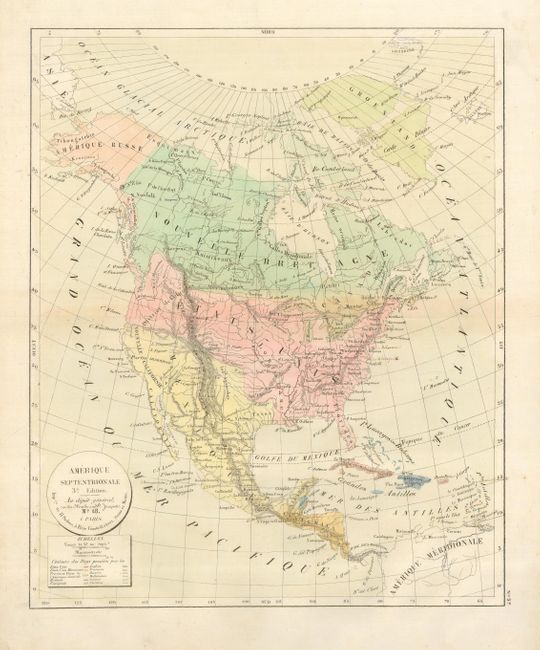
The United States and Great Britain established in 1818 joint claim over the Oregon Territory - the region north of Spanish controlled Upper California up to the southern boundary of Russia's Alaska Territory at North latitude 54°40'. By the late 1830's this arrangement was beginning to fall apart.
In the 1840's the expansionist Democrats, including their 1844 presidential candidate, James Polk, claimed the entire region for the United States. Their expansionist desires were expressed by Polk's famous campaign slogan, "Fifty-four Forty or Fight!" The slogan also became a rally cry for Americans desiring to settle the territory. Following Polk's election, the dispute was resolved by the 1846 Treaty of Oregon, which struck a compromise that fixed the U.S./Canadian boundary at 49º North.
An interesting copper engraved map that shows the Independent Republic of Texas even though the coloring suggests it is under the control of Mexico. This French map portrays the United States extending well into British Columbia, which was eventually known as the Fifty-four Forty or Fight controversy, cartographically taking the side of the United States. Alaska is Amerique Russe and all of Canada is Nouvelle Bretagne. Mexico controls the Southwest. Regional and colonial ownership is shown via hand coloring as given by the key at lower left beneath the title cartouche. An uncommon map by a seldom seen publisher.
References:
Condition: B
Fine impression on hand laid paper with wide, original margins. Fine original coloring with a very light wash in the oceans. Very light brown manuscript place names, two in the Caribbean and two in the Northeast.