Subject: United States
Period: 1859 (dated)
Publication: Atlas of the World
Color: Hand Color
Size:
26.5 x 15.5 inches
67.3 x 39.4 cm
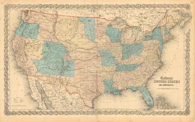
A very scarce map of the United States from the rare 1859/60 Colton atlas. This is the only American atlas map to show Colona. With superb provisional western territorial boundaries including Dakota Territory laying in the region between Minnesota and the Missouri River, and Nebraska taking in the rest of the region up to the Rocky Mountains. Kanzas Territory borders Utah and New Mexico in the west. The proposed Colona Territory (present-day Colorado) is shown by dotted line. Washington Territory wraps around Oregon taking in present-day Idaho. Most unusual is a proposed Nevada Territory with its eastern border along the 114th meridian down to Preuss L., then following the Virgin River to the New Mexican boundary. The proposed Arizona Territory is shown in the southern part of New Mexico. Several exploration routes are shown, including Fremont, Marcy, and Kearney, the Oregon Route, and more. This is by far the best mid-nineteenth century map of the United States published in atlas format. Published by Johnson & Browning. Dated 1859, but likely published in 1860.
References:
Condition: B
Good impressions, colors slightly faded, full margins. Margins toned from matting burn, extra crease beside centerfold, small closed tear in lower margin along centerfold.