Subject: Oklahoma
Period: 1879 (dated)
Publication:
Color: Printed Color
Size:
32 x 24 inches
81.3 x 61 cm
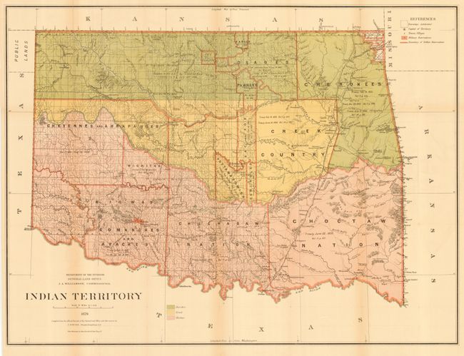
A great map in this series of General Land Office maps reflecting the status of lands allocated to various tribes (color-coded). Indian removals from 'home lands' began as early as 1817 and in the years following many of the principal eastern Indian tribes were relocated. By 1879, the region was divided into a myriad of Indian nations and reservations, all but the smallest of which are annotated here with references to one or more treaties relating to their formation. The map is filled with fascinating detail of early forts, settlements, roads and trails. The Missouri, Kansas & Texas Railroad runs through the territory from Chetopa, Kansas to Denison, Texas and the Atlantic Pacific Railroad's proposed route is shown. Of particular interest are the many early roads and trails: Abilene Cattle Trail, Road to Arkansas City, Road from Cheyenne Agency to Camp Supply, Chisholm's Cattle Trail, Stage Road to Boggy Depot - to name just a few. There is a Negro Settlement near the site of Lexington. Does not include the panhandle, which by this time is Public Lands as noted to the left of the map. Drawn by C. Roeser, Principle Draughtsman for the General Land Office.
References:
Condition: B
Originally issued folding, now backed with archival tissue. Some toning along folds, else very good.