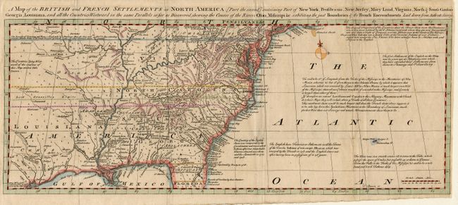
Subject: Colonial United States and Canada
Period: 1755 (published)
Publication: General Magazine of Arts & Sciences
Color: Hand Color
Size:
19.2 x 7.5 inches
48.8 x 19.1 cm
This uncommon map is the second of a two-part map covering from Long Island through northern Florida and extending well west of the Mississippi. It was issued just prior to the French and Indian War and presents a decidedly British point of view with the "Bounds of Virginia and New England by Charters May 28, 1609 and Nov. 3, 1620 extending from the Atlantic Ocean to the South Sea out of which our other Colonies were granted." Lord Granville's Limits are also shown extending past the western edge of the map and the Bounds of Carolina stretch well into Florida. Interesting historical and descriptive notes and early place names fill the map.
References: Jolly GENMAS-69; Sellers and Van Ee #81.
Condition: B
Folds as issued with tissue reinforcement of a couple tiny splits. Bit a very minor foxing.