Subject: Colorado, Kansas, Nebraska
Period: 1860 (published)
Publication: American State Papers
Color: Hand Color
Size:
17.5 x 10 inches
44.5 x 25.4 cm
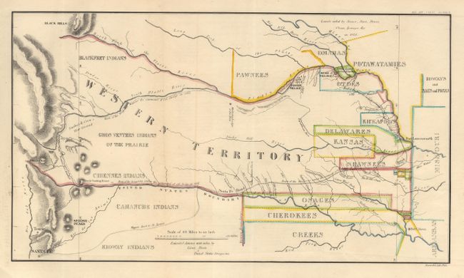
Finely colored map detailing the 1835 expedition of Dragoons under the command of Colonel Henry P. Dodge. The map, attributed to Lt. Steen, extends from Pike's Peak and Santa Fe in the west and east to Fort Leavenworth. The route of the Dragoons is shown stating at Fort Leavenworth and following the Santa Fe Road and then to the Arkansas River (also marked and the U.S./Mexican Boundary) to just before Piles Peak then north through Snake and Crow's War Ground to a return trip along the Platte River. It locates rivers, creeks, mountains, Indian Reservations, Indian villages, Indian lands, military posts, the Santa Fe Trail, etc. Originally published in 1836 in the "Report of the Dragoons under the command of Colonel Henry Dodge to the Rocky Mts. During the summer of 1835" (HR Doc. 181, 24th Cong., 1st Session). A landmark map for illustrating land holdings of the Western Indians.
References: Wheat [TMW] #411 (1835 ed.).
Condition: A
Backed with archival tissue.