Subject: World
Period: 1744 (dated)
Publication:
Color: Hand Color
Size:
16.6 x 12.9 inches
42.2 x 32.8 cm
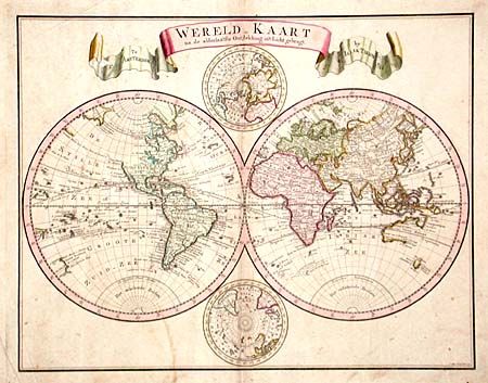
Attractive eighteenth century world map in two hemispheres with smaller polar projections. Geographically up-to-date without any speculative cartography. In the Western Hemisphere the entire Northwest coast of North America is blank and only the western shore of New Zealand is mapped. In the Eastern Hemisphere Nieuw Holland is shown with only the northern and western coastlines and they are connected to New Guinea. Van Diemens Land is shown with several place names. Title in large ribbon style cartouche.
References:
Condition: B
Old repair on center fold in blank margin. Surface soiling along centerfold and a couple of light stains and light creases, else very good.