Catalog Archive
Auction 102, Lot 133

"Nouvelle Carte des Etats-Unis, des Haut et Bas-Canada de la Nouv. Le Escosse, du Nouv. au Brunswick, de Terre-Neuve…", Brue, Adrien Hubert

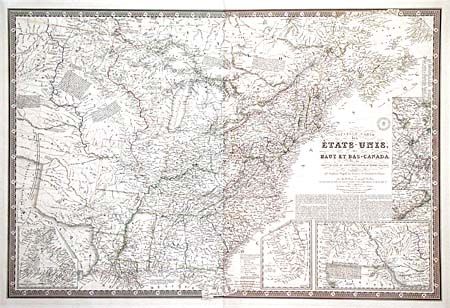
Subject: Eastern United States and Canada

Period: 1836 (dated)

Publication:

Color: Hand Color

Size:
36.5 x 24.5 inches
92.7 x 62.2 cm
Download High Resolution Image
(or just click on image to launch the Zoom viewer)

Scarce map showing the United States east of the Texas panhandle with the central part of the country divided into the Ozark, Osage, Sioux, Huron and Mandan Districts. The map is beautifully engraved and incredibly detailed particularly of the roads and railroads. Notations throughout concerning the Indian tribes, river courses, and early western trails. Includes seven insets: Newfoundland, Southern Florida, Western United States, Philadelphia & Trenton vicinity, New York City vicinity, Boston vicinity and Baltimore & Washington. All surrounded in a bold keyboard style border. Printed on thick paper with the embossed seal of the Brue firm.

References:

Condition: A

A few minor repaired tears in blank margins. Overall very good for such a large map.

Estimate: $1,500 - $1,700

Unsold

Closed on 3/5/2003

Archived