Subject: France
Period: 1820 (dated)
Publication:
Color: Black & White
Size:
30 x 22 inches
76.2 x 55.9 cm
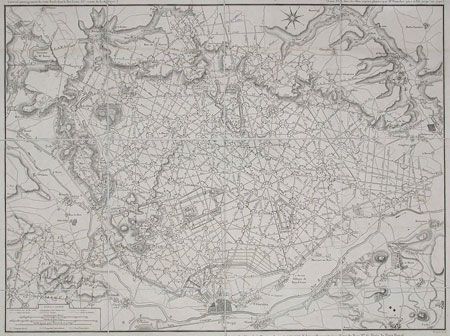
The town of Compiegne on the River Oise is shown bottom center of the map with south oriented to the top. From the town a geometric network of roads and pathways fans out through the royal woods in neat 18th century style. Superb detail with higher elevations shown by hachures, royal domains, properties, individual woods, and plantations all noted. Communities beyond the confines of the forest are also marked with their individual houses. A very thorough and absorbing description of a royal domain, at the time of the French Revolution when its owner was losing his head. The map was originally drawn by Bussac in 1772, here updated by Brue and published by Goujon. Dissected and linen backed folding plan with ribbon edge and vellum tab with manuscript title in brown ink.
References:
Condition: A
Tiny bit of faint toning. Part of ribbon lacking. Overall very good for a folding map.