Subject: World
Period: 1755 (published)
Publication: Gentleman's Magazine
Color: Black & White
Size:
11.2 x 7.2 inches
28.4 x 18.3 cm
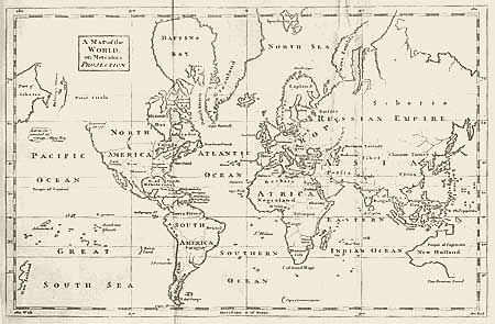
Jolly called this "a neatly executed map showing the state of discovery with little fanciful speculation." The west coast of North American is labeled New Albion and a note in the Pacific reads "Land discovered in 1741, see Gent. Mag. Vol. 24." The entire eastern coast of Australia is indicated as unknown by a dotted line and Van Diemens Land is still connected to the continent. Only the western side of New Zealand is shown. Cape Circumcision floats alone in the south Atlantic well below the Cape of Good Hope. Still bound in the original December 1755 issue that includes an article on the map.
References: Jolly GENT-94.
Condition: B
Good impression on hand laid paper with fabulous watermark. Evenly toned and one soft crease, else very good.