Catalog Archive
Auction 100, Lot 208

"Post Route Map of the States of North Carolina and South Carolina with Adjacent Parts of Georgia, Tennessee, Kentucky, West Virginia and Virginia", Haake, von, A.

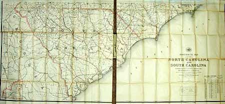
Subject: North and South Carolina

Period: 1895 (dated)

Publication:

Color: Printed Color

Size:
60.3 x 27.3 inches
153.2 x 69.3 cm
Download High Resolution Image
(or just click on image to launch the Zoom viewer)

Folding map in original cloth covers with gilt and embossing. Map in two sections, attached to boards. Large-scale map (five miles to the inch) of the state showing the various postal routes with frequency of delivery noted (from once to six times a week), special supply routes and mail message routes. The current and discontinued offices are located. Inset table lists the counties. The map was made in 1883 by Alexander von Haake, of the Topographical Engineering Dept. and updated for Postmaster General William L. Wilson to Sept. 1, 1895. Inset "Western Part of North Carolina."

References:

Condition: C

Minor toning of folds with several separations, without apparent loss. Paper is toned, else good.

Estimate: $250 - $300

Sold for: $300

Closed on 9/12/2002

Archived