Subject: World
Period: 1670 (circa)
Publication:
Color: Hand Color
Size:
17.8 x 13 inches
45.2 x 33 cm
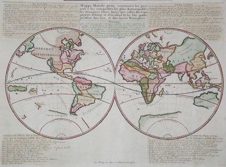
Scarce and unusual double hemisphere map with Dutch text describing the travels & colonial possessions of the Dutch East India Company and other trading companies. The world is shown in simple form with California as an Island. The principal countries are named and other locations are numbered and related to the keys above and below the map. The numbers 1 to 34 and the text refer to the voyages by Dutch explorers from 1594 (the first attempt to locate a Northeast Passage) to 1665 (when New York was recaptured by the British). Items 35-47 describe the Dutch colonial possessions in Asia. Published by Jean Malherbe. Listed by Shirley as scarce.
References: Shirley #447.
Condition: A
Expert and invisible repair of tiny fold separations.