Showing Featured Lots(remove filter)
Filtered by Category:United States(Show All Categories)
Catalog Archive
2249 lots
Page 1 of 45
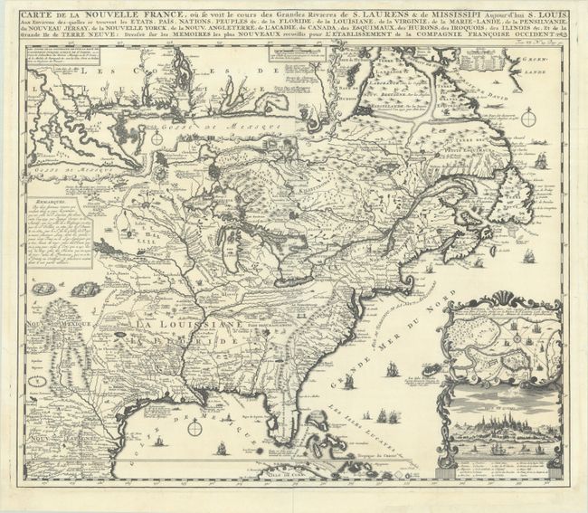
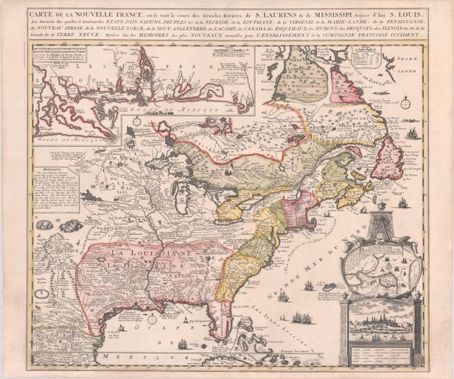
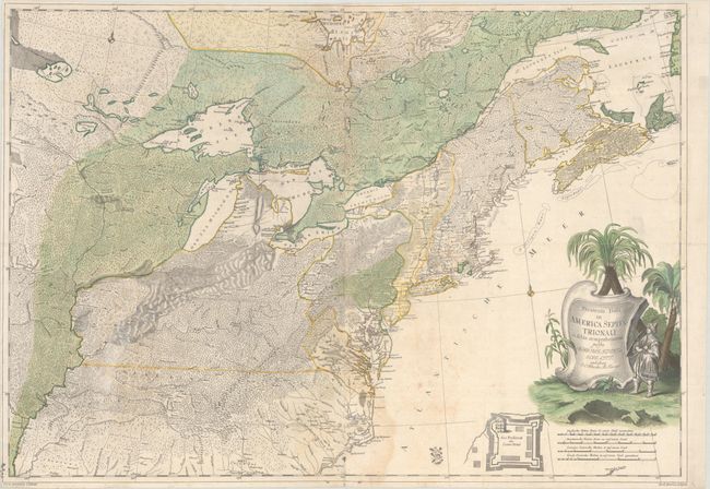
Auction 204, Lot 95
Subject: Colonial Eastern United States & Canada
Chatelain, Henry Abraham
Carte de la Nouvelle France, ou se Voit le Cours des Grandes Rivieres de S. Laurens & de Mississipi Aujour d'hui S. Louis, aux Environs des-quelles se Trouvent les Etats, Pais, Nations, Peuples, &c. de la Floride, de la Louisiane, de la Virginie..., 1719
Size: 19.3 x 16.7 inches (49 x 42.4 cm)
Estimate: $2,200 - $2,500
One of the Most Informative 18th Century Maps of the French Possessions in North America
Unsold
Closed on 6/18/2025
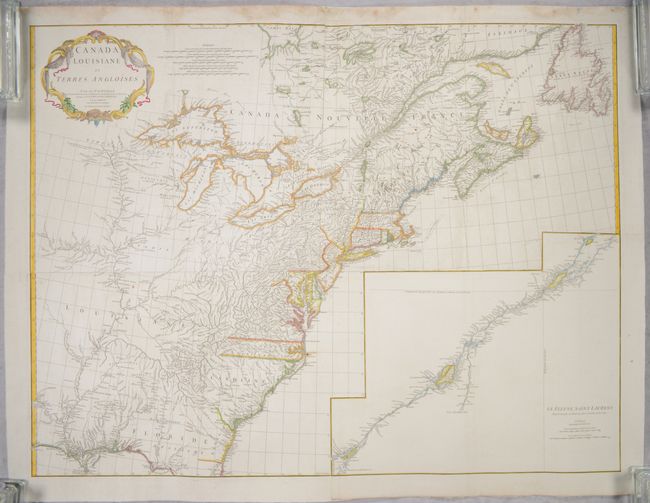
Auction 204, Lot 96
Subject: Colonial Eastern United States & Canada
Anville, Jean Baptiste Bourguignon d'
[On 4 Joined Sheets] Canada Louisiane et Terres Angloises, 1755
Size: 44.8 x 33.9 inches (113.8 x 86.1 cm)
Estimate: $1,400 - $1,700
D'Anville's Spectacular Map of Eastern Seaboard on 4 Joined Sheets
Sold for: $1,000
Closed on 6/18/2025

Auction 204, Lot 104
Subject: Northeastern United States & Canada
Bouchette, Joseph
[Eastern Sheet] Map of the Provinces of Upper & Lower Canada with the Adjacent Parts of the United States of America &c. Compiled from the Latest Surveys and Adjusted from the Most Recent and Approved Astronomical Observations, 1815
Size: 24.3 x 30 inches (61.7 x 76.2 cm)
Estimate: $2,400 - $3,000
Eastern Sheet of Bouchette's Rare Map Presenting Lower Canada and New England
Unsold
Closed on 6/18/2025
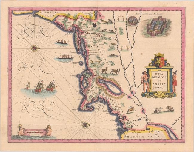
Auction 204, Lot 132
Subject: Colonial New England & Mid-Atlantic United States
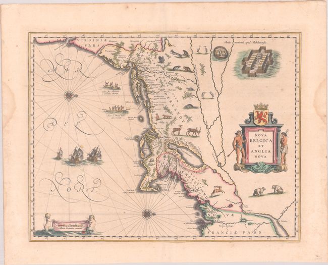
Blaeu, (Family)
Nova Belgica et Anglia Nova, 1638
Size: 19.9 x 15.3 inches (50.5 x 38.9 cm)
Estimate: $1,600 - $1,900
Important Map of Colonial New England and the Mid-Atlantic
Unsold
Closed on 6/18/2025
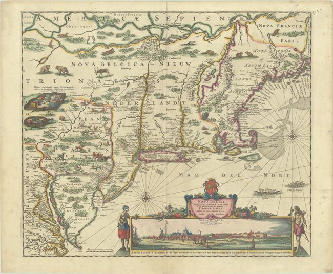
Auction 204, Lot 133
Subject: Colonial New England & Mid-Atlantic United States
Danckerts, Justus
Novi Belgii Novaeque Angliae nec non Pennsylvaniae et Partis Virginiae Tabula Multis in Locis Emendata, 1690
Size: 21.4 x 18.2 inches (54.4 x 46.2 cm)
Estimate: $4,000 - $4,750
Danckerts' Decorative Map with Early View of New York City in Full Contemporary Color
Sold for: $3,000
Closed on 6/18/2025
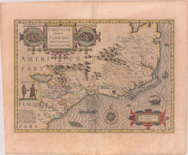
Auction 204, Lot 141
Subject: Colonial Southeastern United States
Hondius, Jodocus
Virginiae Item et Floridae Americae Provinciarum, Nova Descriptio, 1619
Size: 19.1 x 13.5 inches (48.5 x 34.3 cm)
Estimate: $1,400 - $1,700
A Seminal Map of the Southeast and Early American Cartography in Full Contemporary Color
Unsold
Closed on 6/18/2025
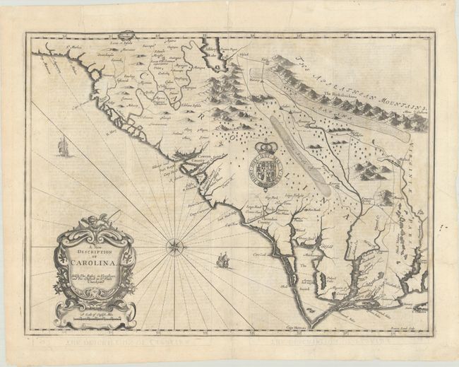
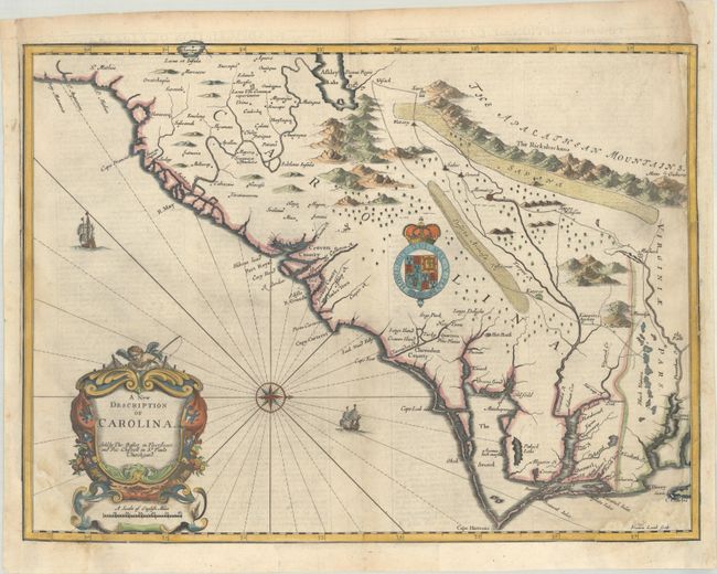
Auction 204, Lot 143
Subject: Colonial Southeastern United States
Speed/Lamb
A New Description of Carolina, 1676
Size: 19.8 x 14.8 inches (50.3 x 37.6 cm)
Estimate: $1,800 - $2,100
Speed's Map of the Carolinas Based Upon the Lords Proprietor's Map
Sold for: $650
Closed on 6/18/2025
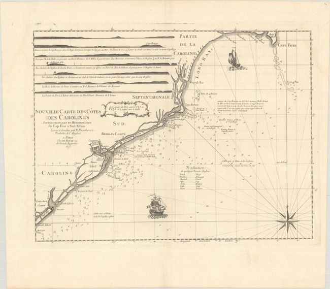
Auction 204, Lot 146
Subject: Colonial Southeastern United States
Le Rouge, George Louis
Nouvelle Carte des Cotes des Carolines Septentrionales et Meridionales du Cap Fear a Sud Edisto..., 1777
Size: 21.3 x 16.1 inches (54.1 x 40.9 cm)
Estimate: $1,000 - $1,300
Rare French Chart of the Carolina Coast
Sold for: $375
Closed on 6/18/2025
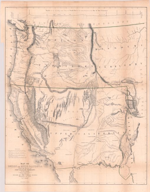
Auction 204, Lot 155
Subject: Western United States
Fremont/Preuss
[Map with Report] Map of Oregon and Upper California from the Surveys of John Charles Fremont and Other Authorities [with] Geographical Memoir upon Upper California..., 1849
Size: 26.7 x 33.3 inches (67.8 x 84.6 cm)
Estimate: $1,500 - $1,800
Fremont's Map of the American West with Report
Sold for: $1,100
Closed on 6/18/2025
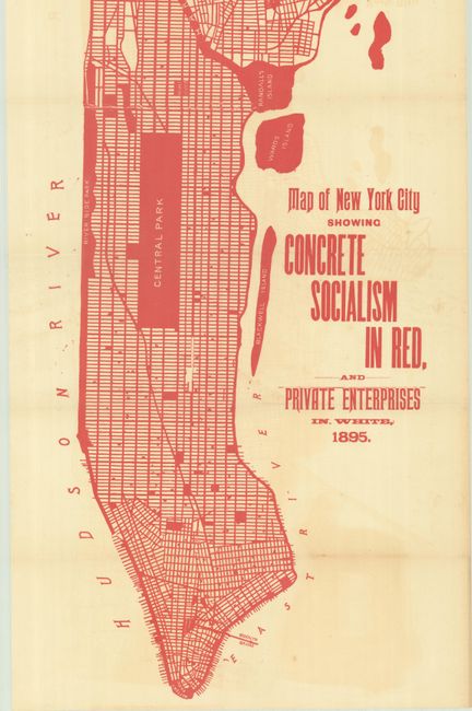
Auction 204, Lot 226
Subject: New York City, New York
Map of New York City Showing Concrete Socialism in Red, and Private Enterprises in White, 1895
Size: 13 x 39 inches (33 x 99.1 cm)
Estimate: $400 - $600
"A Powerful Example of Color Used to Make a Point" - PJ Mode
Sold for: $250
Closed on 6/18/2025
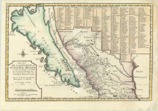
Auction 204, Lot 255
Subject: Southwestern United States & Mexico, California
Fer, Nicolas de
Cette Carte de Californie et du Nouveau Mexique, est Tiree de Celle qui a ete Envoyee par un Grand d'Espagne pour etre Communiquee a Mrs. de l'Academie Royale des Sciences, 1700
Size: 13.4 x 9 inches (34 x 22.9 cm)
Estimate: $1,100 - $1,400
De Fer's Important Map of the Island of California - First State
Sold for: $800
Closed on 6/18/2025
Auction 203, Lot 86
Subject: Colonial Eastern United States & Canada
Fer, Nicolas de
Carte de la Nouvelle France, ou se Voit le Cours des Grandes Rivieres de S. Laurens & de Mississipi Aujour d'hui S. Louis, aux Environs des-quelles se Trouvent les Etats, Pais, Nations, Peuples, &c. de la Floride, de la Louisiane, de la Virginie..., 1720
Size: 21.9 x 19.8 inches (55.6 x 50.3 cm)
Estimate: $2,750 - $3,500
Striking Map of French Colonial Possessions
Sold for: $2,200
Closed on 4/23/2025
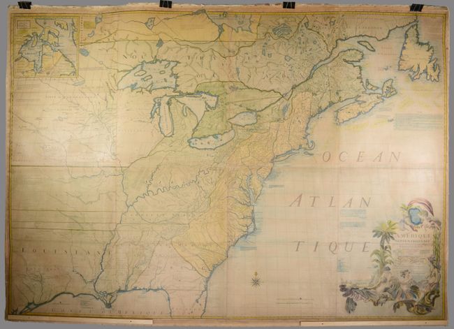
Auction 203, Lot 89
Subject: Colonial Eastern United States & Canada
Mitchell/Le Rouge
Amerique Septentrionale avec les Routes, Distances en Miles, Villages et Etablissements Francois et Anglois par le Docteur Mitchel, 1777
Size: 75 x 52.4 inches (190.5 x 133.1 cm)
Estimate: $9,500 - $12,000
Third French Edition of Mitchell's Monumental Map
Sold for: $5,000
Closed on 4/23/2025
Auction 203, Lot 95
Subject: Colonial Northeastern United States & Canada
Rhode, Johann Cristoph
Theatrum Belli in America Septentrionali II. Foiliis Comprehensum..., 1755
Size: 31.5 x 22 inches (80 x 55.9 cm)
Estimate: $8,000 - $9,500
Scarce German Map Illustrating the French & Indian War
Sold for: $5,000
Closed on 4/23/2025
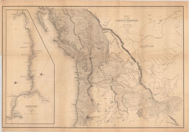
Auction 203, Lot 103
Subject: Northwestern United States & Canada
Wilkes, Charles
Map of the Oregon Territory by the U.S. Ex. Ex., 1841
Size: 34.1 x 22.9 inches (86.6 x 58.2 cm)
Estimate: $1,400 - $1,700
One of the Most Detailed and Important 19th-Century Maps of the American Northwest
Sold for: $1,100
Closed on 4/23/2025
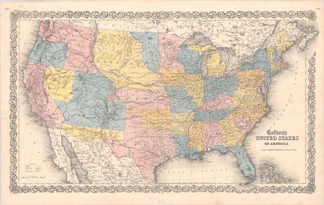
Auction 203, Lot 108
Subject: United States
Johnson & Browning
Colton's United States of America, 1859
Size: 26.5 x 15.7 inches (67.3 x 39.9 cm)
Estimate: $750 - $900
Scarce Map Featuring Colona
Sold for: $650
Closed on 4/23/2025
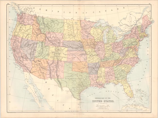
Auction 203, Lot 112
Subject: United States, Pembina
Bartholomew, John
General Map of the United States, 1875
Size: 22.3 x 16.6 inches (56.6 x 42.2 cm)
Estimate: $275 - $350
Scarce Map Depicting the Territory of Pembina
Unsold
Closed on 4/23/2025
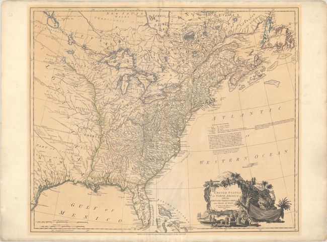
Auction 203, Lot 130
Subject: Eastern United States
Faden, William
The United States of North America: with the British Territories, and Those of Spain, According to the Treaty, of 1784, 1796
Size: 25 x 20.9 inches (63.5 x 53.1 cm)
Estimate: $4,000 - $4,750
Features the State of Franklin
Sold for: $2,500
Closed on 4/23/2025
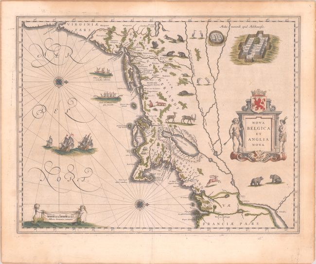
Auction 203, Lot 139
Subject: Colonial New England & Mid-Atlantic United States
Blaeu, (Family)
Nova Belgica et Anglia Nova, 1643
Size: 19.9 x 15.3 inches (50.5 x 38.9 cm)
Estimate: $1,900 - $2,200
Important Map of Colonial New England and the Mid-Atlantic in Full Contemporary Color
Sold for: $1,400
Closed on 4/23/2025
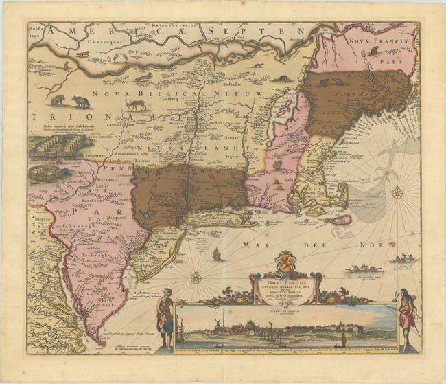
Auction 203, Lot 140
Subject: Colonial New England & Mid-Atlantic United States
Visscher, Nicolas
Novi Belgii Novaeque Angliae nec non Partis Virginiae Tabula Multis in Locis Emendata, 1683
Size: 21.8 x 18.3 inches (55.4 x 46.5 cm)
Estimate: $3,250 - $4,000
Visscher's Influential Map with Early View of New York City
Sold for: $2,000
Closed on 4/23/2025
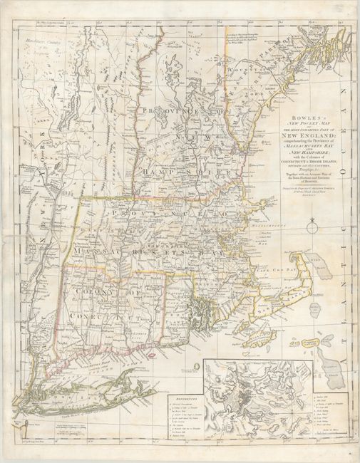
Auction 203, Lot 143
Subject: Colonial New England United States
Bowles, Carrington
Bowles's New Pocket Map of the Most Inhabited Part of New England; Comprehending the Provinces of Massachusets Bay and New Hampshire; with the Colonies of Connecticut & Rhode Island..., 1776
Size: 20.8 x 25.4 inches (52.8 x 64.5 cm)
Estimate: $3,750 - $4,500
Reduced-Size Edition of Jefferys/Mead Map with Revolutionary War Updates
Sold for: $2,750
Closed on 4/23/2025
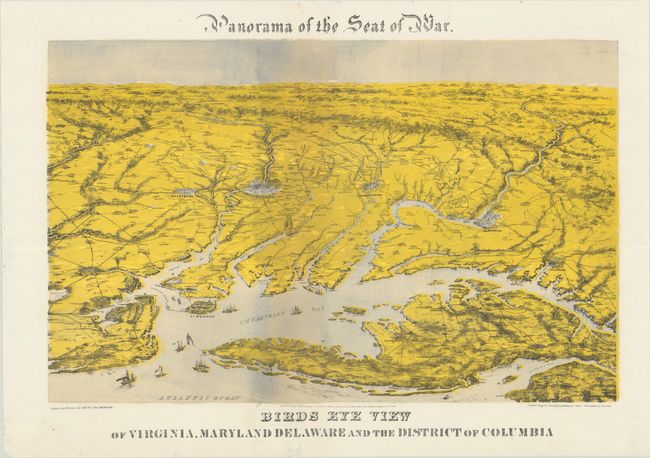
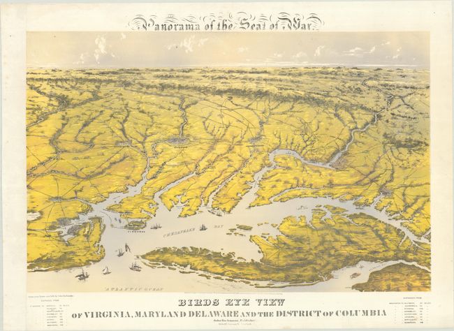
Auction 203, Lot 149
Subject: Mid-Atlantic United States, Civil War
Bachmann, John
Panorama of the Seat of War. Birds Eye View of Virginia, Maryland Delaware and the District of Columbia, 1864
Size: 28.3 x 18 inches (71.9 x 45.7 cm)
Estimate: $1,200 - $1,500
Bachmann's Dramatic View of the Mid-Atlantic Region
Unsold
Closed on 4/23/2025
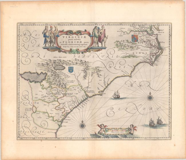
Auction 203, Lot 153
Subject: Colonial Southeastern United States
Blaeu, Willem
Virginiae Partis Australis, et Floridae Partis Orientalis, Interjacentiumq Regionum Nova Descriptio, 1642
Size: 20 x 15.3 inches (50.8 x 38.9 cm)
Estimate: $1,000 - $1,300
Blaeu's Decorative Map of the Southeast in Full Contemporary Color
Unsold
Closed on 4/23/2025
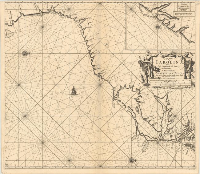
Auction 203, Lot 154
Subject: Colonial Southeastern United States
Keulen, Johannes van
Pas Kaart van de Kust van Carolina Tusschen C de Canaveral en C Henry, 1702
Size: 23 x 20.3 inches (58.4 x 51.6 cm)
Estimate: $2,000 - $2,400
Scarce Dutch Chart of the Carolinas
Sold for: $1,100
Closed on 4/23/2025
Auction 203, Lot 156
Subject: Southeastern United States
Bartram, William
Travels Through North & South Carolina, Georgia, East & West Florida, the Cherokee Country, the Extensive Territories of the Muscogulges, or Creek Confederacy, and the Country of the Chactaws..., 1791
Size: 5.9 x 9.8 inches (15 x 24.9 cm)
Estimate: $8,000 - $9,500
Complete First Edition of Bartram's Work on the American Southeast
Unsold
Closed on 4/23/2025
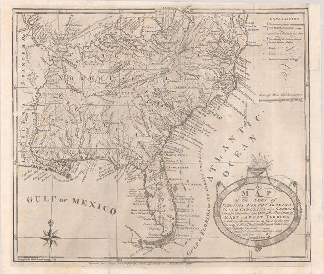
Auction 203, Lot 161
Subject: Southern United States, Franklin
Purcell, Joseph
A Map of the States of Virginia North Carolina South Carolina and Georgia Comprehending the Spanish Provinces of East and West Florida Exhibiting the Boundaries as Fixed by the Late Treaty of Peace Between the United States and the Spanish Dominions..., 1788
Size: 14.6 x 12.6 inches (37.1 x 32 cm)
Estimate: $1,000 - $1,300
Rare First State of Purcell's Map Locating the Proposed State of Franklin
Sold for: $750
Closed on 4/23/2025
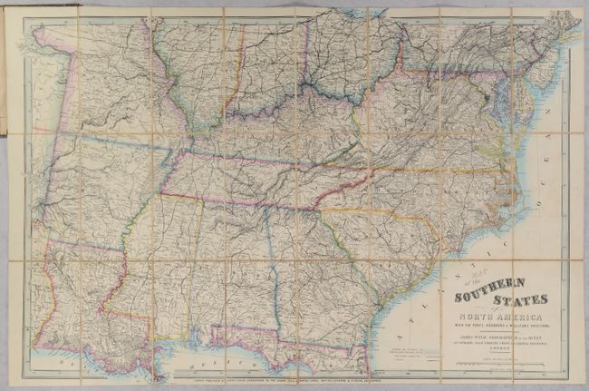
Auction 203, Lot 164
Subject: Southern United States, Civil War
Wyld, James
Map of the Southern States of North America with the Forts, Harbours & Military Positions, 1861
Size: 40.9 x 26.8 inches (103.9 x 68.1 cm)
Estimate: $1,600 - $1,900
Scarce Civil War Map for a British Audience
Unsold
Closed on 4/23/2025
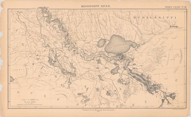
Auction 203, Lot 168
Subject: Mississippi River
Preliminary Map of the Lower Mississippi River from the Mouth of the Ohio River to the Head of the Passes in Thirty Two Sheets, 1881-85
Size: 23.8 x 14.8 inches (60.5 x 37.6 cm)
Estimate: $1,600 - $1,900
A Remarkable Production by the Newly Established Mississippi River Commission
Sold for: $800
Closed on 4/23/2025
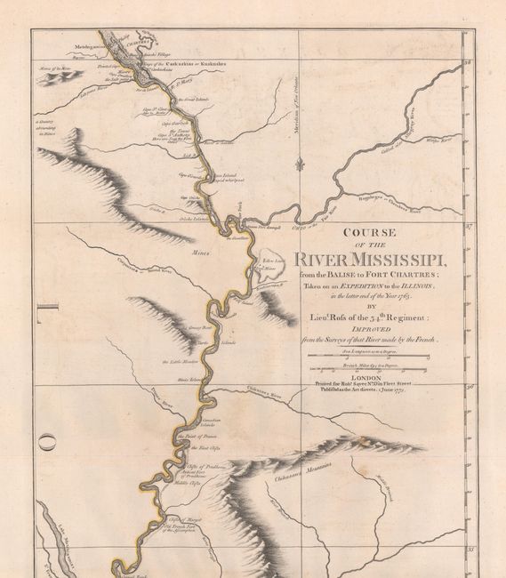
Auction 203, Lot 169
Subject: Colonial Central United States, Mississippi River
Ross, John (Lt.)
Course of the River Mississipi, from the Balise to Fort Chartres; Taken on an Expedition to the Illinois, in the Latter End of the Year 1763..., 1775
Size: 13.6 x 44.2 inches (34.5 x 112.3 cm)
Estimate: $2,750 - $3,500
First English Map of the Lower Mississippi River
Sold for: $1,400
Closed on 4/23/2025
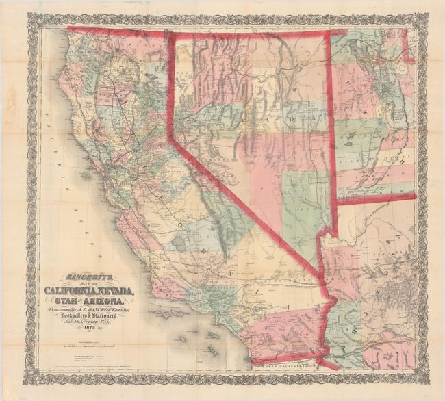
Auction 203, Lot 189
Subject: Southwestern United States
Bancroft, A.L. & Company
Bancroft's, Map of California, Nevada, Utah and Arizona, 1873
Size: 32.8 x 30.2 inches (83.3 x 76.7 cm)
Estimate: $1,100 - $1,400
From the Greatest Map Publisher of the Pacific Coast
Sold for: $1,900
Closed on 4/23/2025
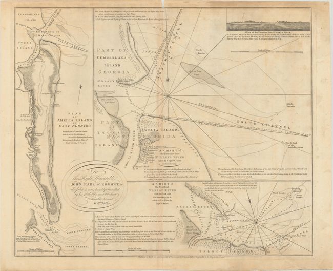
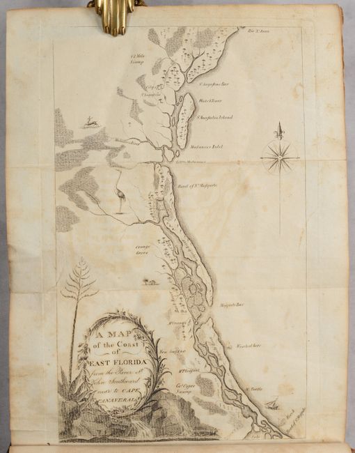
Auction 203, Lot 229
Subject: Amelia Island, Florida
Jefferys, Thomas
A Chart of the Entrance into St. Mary's River Taken by Captn. W. Fuller in November 1769 [on sheet with] Plan of Amelia Island in East Florida [and] A Chart of the Mouth of Nassau River... , 1770
Size: 24.1 x 20 inches (61.2 x 50.8 cm)
Estimate: $2,400 - $3,000
Important Charts Detailing Amelia Island and Surrounding Rivers
Unsold
Closed on 4/23/2025
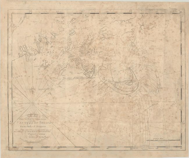
Auction 203, Lot 249
Subject: Southern Massachusetts, Martha's Vineyard & Nantucket Island
Norman, John
Chart from New York to Timber Island Including Nantucket Shoals from the Latest Surveys..., 1791
Size: 20.3 x 16.3 inches (51.6 x 41.4 cm)
Estimate: $2,750 - $3,500
Title Sheet of John Norman's Rare Chart of the New England Coastline, Featuring Martha's Vineyard and Nantucket Island
Sold for: $5,500
Closed on 4/23/2025
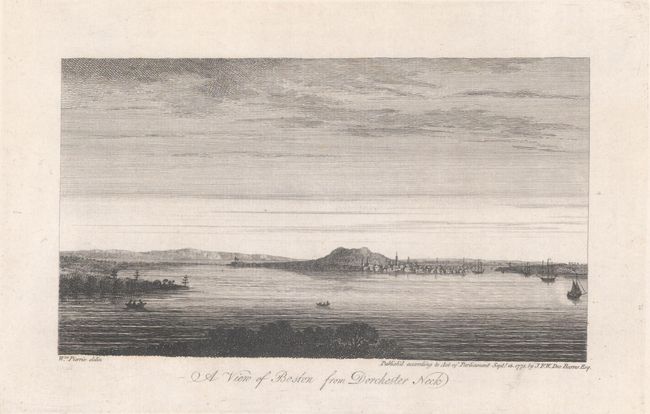
Auction 203, Lot 254
Subject: Boston, Massachusetts
Des Barres, Joseph Frederick Wallet
[On 2 Sheets - 6 Views of Boston], 1775
Size: 24.9 x 33.4 inches (63.2 x 84.8 cm)
Estimate: $2,750 - $3,500
Rare Set of Revolutionary War Period Views of Boston
Sold for: $2,100
Closed on 4/23/2025
Auction 203, Lot 264
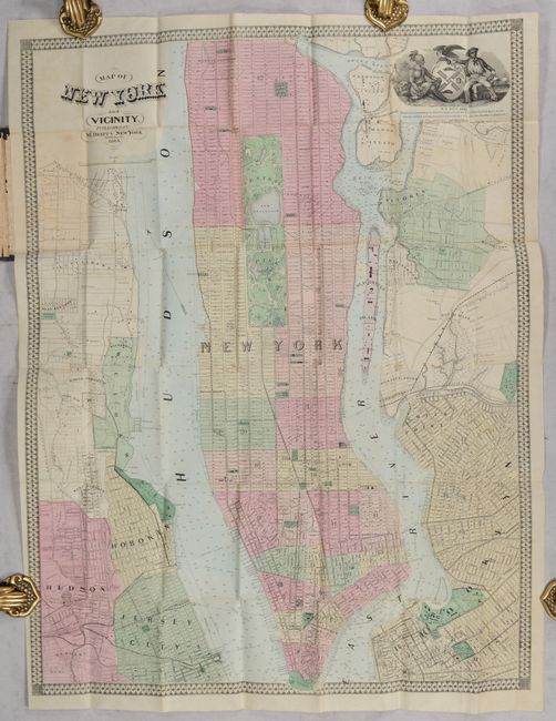
Subject: New York City, New York
Dripps, Matthew
Map of New York and Vicinity, 1863
Size: 19.1 x 25.1 inches (48.5 x 63.8 cm)
Estimate: $750 - $900
Rare Dripps's Pocket Map of Manhattan Featuring Central Park Still Under Construction
Sold for: $500
Closed on 4/23/2025
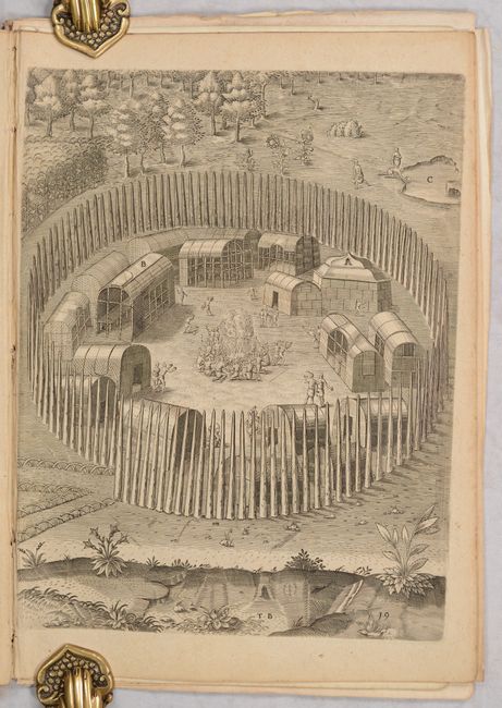
Auction 203, Lot 296
Subject: Virginia, Native Americans
Bry, Theodore de
[Grands Voyages, Part I] Admiranda Narratio Fida Tamen, de Commodis et Incolarum Ritibus Virginiae, Nuper Admodum ab Anglis..., 1608
Size: 9.1 x 13.7 inches (23.1 x 34.8 cm)
Estimate: $2,300 - $2,750
Set of De Bry's Native Virginians & Picts from Part I of Grands Voyages
Sold for: $1,700
Closed on 4/23/2025
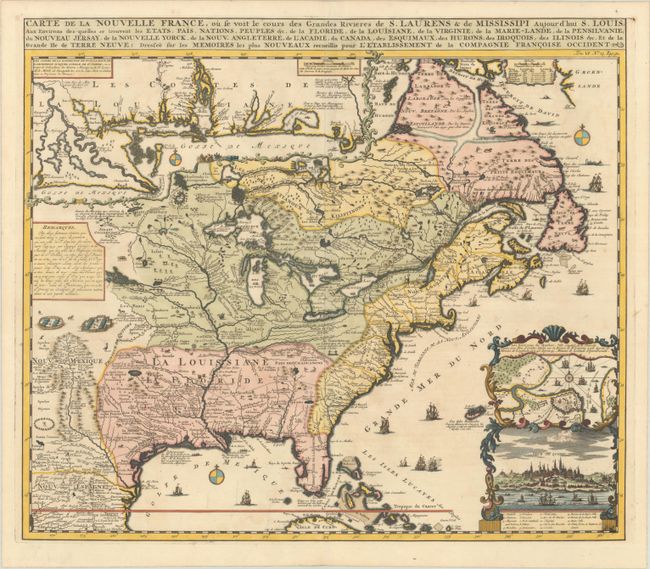
Auction 202, Lot 102
Subject: Colonial Eastern United States & Canada
Chatelain, Henry Abraham
Carte de la Nouvelle France, ou se voit les Cours des Grandes Rivieres de S. Laurens & de Mississipi Aujour d'hui S. Louis, aux Environs des quelles se Trouvent les Etats, Pais, Nations, Peuples &c. de la Floride, de la Louisiane, de la Virginie..., 1719
Size: 19 x 16.5 inches (48.3 x 41.9 cm)
Estimate: $3,000 - $3,750
One of the Most Informative 18th Century Maps of the French Possessions in North America
Sold for: $2,000
Closed on 2/12/2025
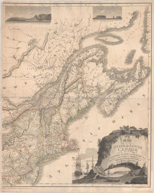
Auction 202, Lot 106
Subject: Northeastern United States & Canada
Bouchette, Joseph
[Eastern Sheet] Map of the Provinces of Upper & Lower Canada with the Adjacent Parts of the United States of America &c. Compiled from the Latest Surveys and Adjusted from the Most Recent and Approved Astronomical Observations, 1815
Size: 24.3 x 30 inches (61.7 x 76.2 cm)
Estimate: $2,750 - $3,500
Eastern Sheet of Bouchette's Rare Map Presenting Lower Canada and New England
Unsold
Closed on 2/12/2025
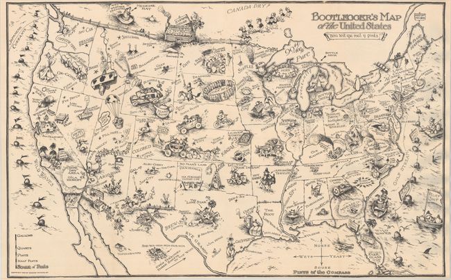
Auction 202, Lot 118
Subject: United States
Bootlegger's Map of the United States, 1926
Size: 33.9 x 21.3 inches (86.1 x 54.1 cm)
Estimate: $1,100 - $1,400
McCandlish's Humorous Prohibition Map
Sold for: $900
Closed on 2/12/2025
Auction 202, Lot 122
Subject: Colonial Eastern United States
Delisle, Guillaume
Carte de la Louisiane et du Cours du Mississipi Dressee sur un Grand Nombre de Memoires Entrau'tres sur ceux de Mr. le Maire, 1718
Size: 25.7 x 19.3 inches (65.3 x 49 cm)
Estimate: $4,750 - $6,000
A Foundation Map for the Mississippi Valley and the First Appearance of Texas on a Printed Map - First Issue
Sold for: $2,650
Closed on 2/12/2025
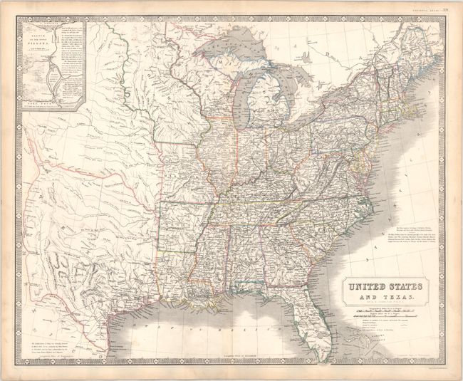
Auction 202, Lot 128
Subject: Eastern United States, Texas
Johnston, Alexander K.
United States and Texas, 1842
Size: 24.3 x 19.8 inches (61.7 x 50.3 cm)
Estimate: $1,200 - $1,500
Scottish Atlas Map Featuring the Independent Republic of Texas
Sold for: $900
Closed on 2/12/2025
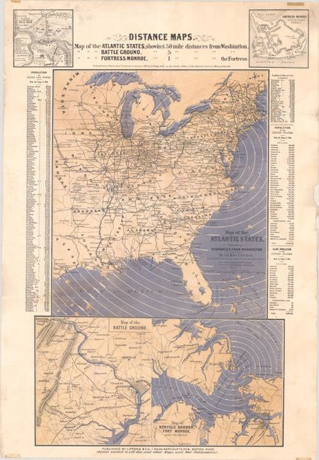
Auction 202, Lot 130
Subject: Eastern United States, Civil War
Prang, Louis
Distance Maps. Map of the Atlantic States Showing 50 Mile Distances from Washington..., 1861
Size: 15 x 22.1 inches (38.1 x 56.1 cm)
Estimate: $1,100 - $1,400
Rare Civil War Distance Map
Sold for: $650
Closed on 2/12/2025
Auction 202, Lot 134
Subject: Colonial New England & Mid-Atlantic United States
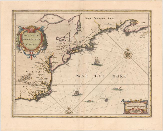
Jansson, Jan
Nova Anglia Novum Belgium et Virginia, 1639
Size: 19.8 x 15.3 inches (50.3 x 38.9 cm)
Estimate: $1,200 - $1,500
First State of Jansson's Influential Map of the East Coast
Sold for: $700
Closed on 2/12/2025
Auction 202, Lot 135
Subject: Colonial New England & Mid-Atlantic United States
Blaeu, Willem
Nova Belgica et Anglia Nova, 1640
Size: 19.8 x 15.3 inches (50.3 x 38.9 cm)
Estimate: $1,900 - $2,200
Important Map of Colonial New England and the Mid-Atlantic in Full Contemporary Color
Sold for: $1,400
Closed on 2/12/2025
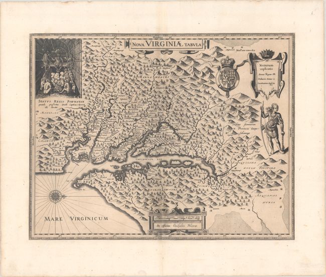
Auction 202, Lot 147
Subject: Colonial Mid-Atlantic United States
Hondius/Blaeu
Nova Virginiae Tabula, 1630
Size: 19.1 x 14.9 inches (48.5 x 37.8 cm)
Estimate: $1,400 - $1,700
One of the Most Important 17th Century Maps of the Chesapeake Bay
Sold for: $1,000
Closed on 2/12/2025
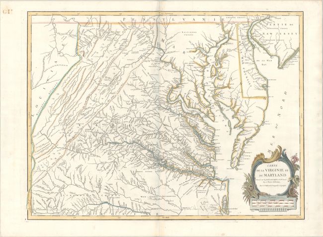
Auction 202, Lot 154
Subject: Mid-Atlantic United States
Robert de Vaugondy, Didier
Carte de la Virginie et du Maryland Dressee sur la Grande Carte Angloise de Mrs. Josue Fry et Pierre Jefferson, 1793
Size: 25.3 x 19 inches (64.3 x 48.3 cm)
Estimate: $1,400 - $1,700
An Essential Map of Virginia and Maryland
Sold for: $1,000
Closed on 2/12/2025
Auction 202, Lot 156
Subject: Mid-Atlantic United States, Civil War
Bachmann, John
Panorama of the Seat of War. Birds Eye View of Virginia, Maryland Delaware and the District of Columbia, 1861
Size: 28.1 x 18.1 inches (71.4 x 46 cm)
Estimate: $1,800 - $2,200
Bachmann's Dramatic View of the Mid-Atlantic Region
Sold for: $1,700
Closed on 2/12/2025
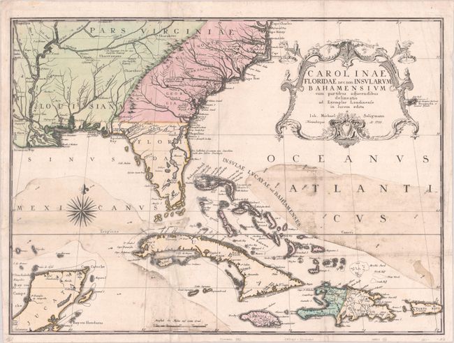
Auction 202, Lot 158
Subject: Colonial Southeastern United States, Bahamas & Greater Antilles
Seligmann, Johann Michael
Carolinae Floridae nec non Insularum Bahamensium cum Partibus Adjacendibus Delineatio ad Exemplar Londinense in Lucem Edita, 1755
Size: 23 x 17 inches (58.4 x 43.2 cm)
Estimate: $3,250 - $4,000
German Edition of Catesby's Scarce and Important Map of the Southeastern United States
Sold for: $2,400
Closed on 2/12/2025

Auction 202, Lot 159
Subject: Colonial Southeastern United States
Hondius, Jodocus
Virginiae Item et Floridae Americae Provinciarum, Nova Descriptio, 1619
Size: 19.1 x 13.5 inches (48.5 x 34.3 cm)
Estimate: $1,400 - $1,700
A Seminal Map of the Southeast and Early American Cartography in Full Contemporary Color
Unsold
Closed on 2/12/2025
Auction 202, Lot 161
Subject: Colonial Southeastern United States
Speed/Lamb
A New Description of Carolina, 1676
Size: 20 x 14.9 inches (50.8 x 37.8 cm)
Estimate: $2,200 - $2,500
Speed's Map of the Carolinas Based Upon the Lords Proprietor's Map
Unsold
Closed on 2/12/2025
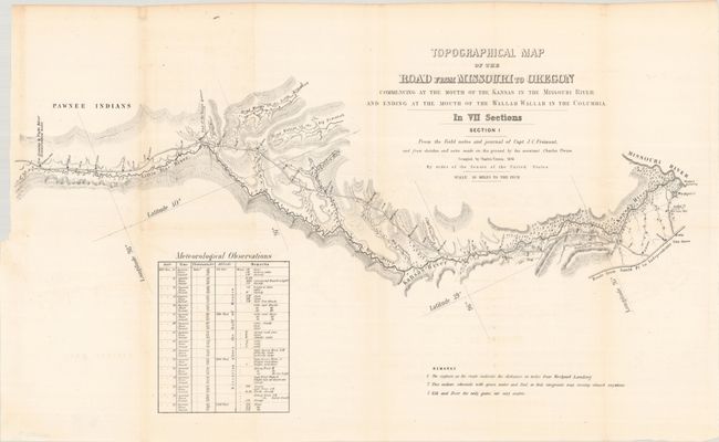
Auction 202, Lot 179
Subject: Western United States
Fremont/Preuss
[Lot of 7] Topographical Map of the Road from Missouri to Oregon Commencing at the Mouth of the Kansas in the Missouri River...In VII Sections... [with] Report No. 145...Canal or Railroad Between the Atlantic and Pacific Oceans, 1849
Size: 24.5 x 12.8 inches (62.2 x 32.5 cm)
Estimate: $3,000 - $3,750
Scarce Seven-Part Oregon Trail Map
Sold for: $3,000
Closed on 2/12/2025
2249 lots
Page 1 of 45