Showing Featured Lots(remove filter)
Filtered by Category:United States(Show All Categories)
Showing results for:Auction 172
Catalog Archive
17 lots
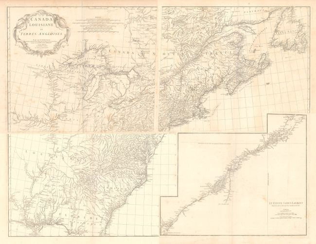
Auction 172, Lot 96
Subject: Colonial Eastern United States & Canada
Anville, Jean Baptiste Bourguignon d'
[On 4 Sheets] Canada Louisiane et Terres Angloises, 1755
Size: 22 x 18.8 inches (55.9 x 47.8 cm)
Estimate: $1,400 - $1,700
D'Anville's Spectacular Map of Eastern Seaboard
Unsold
Closed on 4/17/2019
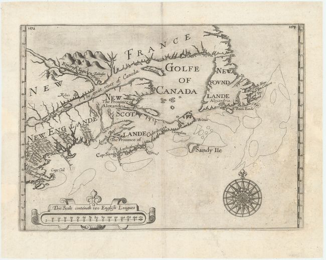
Auction 172, Lot 102
Subject: Colonial Northeastern United States & Canada
Alexander, William (Sir)
[Untitled - Northeastern United States & Canada], 1625
Size: 13.5 x 9.8 inches (34.3 x 24.9 cm)
Estimate: $6,000 - $7,500
The First Map to Name New Scotland
Unsold
Closed on 4/17/2019
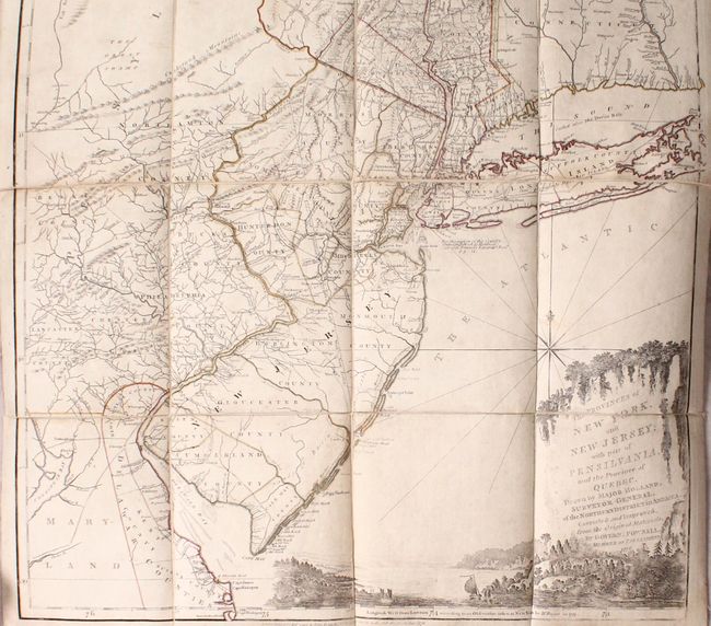
Auction 172, Lot 106
Subject: Colonial Northeastern United States & Quebec
Holland/Pownal
The Provinces of New York, and New Jersey; with Part of Pensilvania, and the Province of Quebec..., 1776
Size: 21.5 x 53.3 inches (54.6 x 135.4 cm)
Estimate: $5,000 - $6,500
Thomas Jefferys' Important Revolutionary War Period Map
Unsold
Closed on 4/17/2019
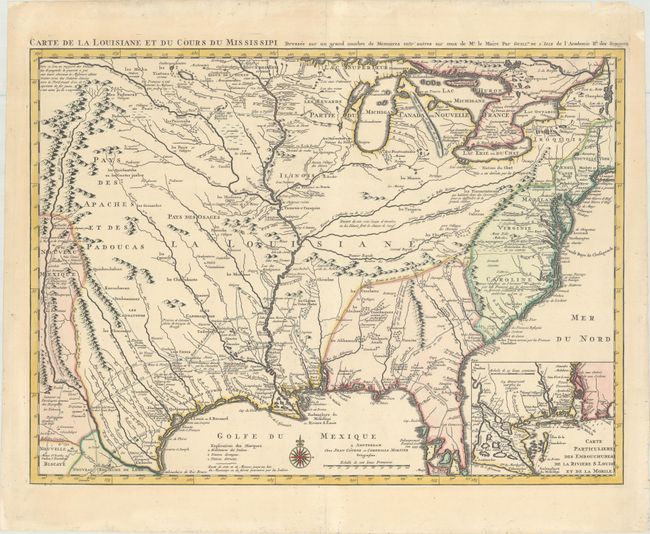
Auction 172, Lot 119
Subject: Colonial Eastern United States, Louisiana Territory
Delisle/Covens & Mortier
Carte de la Louisiane et du Cours du Mississipi Dressee sur un Grand Nombre de Memoires Entr'autres sur ceux de Mr. le Maire, 1730
Size: 23.4 x 17.3 inches (59.4 x 43.9 cm)
Estimate: $1,800 - $2,200
Delisle's Influential Map of the Louisiana Territory
Unsold
Closed on 4/17/2019
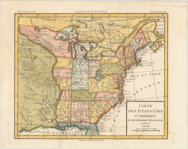
Auction 172, Lot 122
Subject: Eastern United States, Franklin
Brion de la Tour, Louis
Carte des Etats-Unis d'Amerique et du Cours du Mississipi, 1788
Size: 10.6 x 8.6 inches (26.9 x 21.8 cm)
Estimate: $800 - $950
One of the Earliest Maps to Feature the State of Franklin
Sold for: $3,750
Closed on 4/17/2019
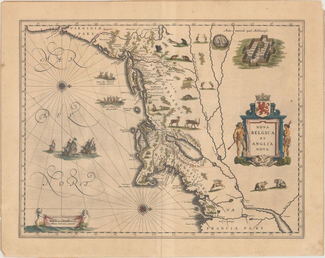
Auction 172, Lot 129
Subject: Colonial New England & Mid-Atlantic United States
Blaeu, Willem
Nova Belgica et Anglia Nova, 1635
Size: 19.9 x 15.3 inches (50.5 x 38.9 cm)
Estimate: $2,200 - $2,500
Important Map of Colonial New England and the Mid-Atlantic in Contemporary Color
Sold for: $1,600
Closed on 4/17/2019
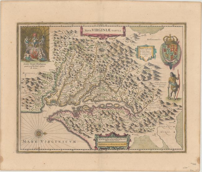
Auction 172, Lot 137
Subject: Colonial Mid-Atlantic United States
Hondius, Henricus
Nova Virginiae Tabula, 1638
Size: 19.4 x 14.9 inches (49.3 x 37.8 cm)
Estimate: $1,800 - $2,200
One of the Most Important 17th Century Maps of the Chesapeake Bay in Full Contemporary Color
Sold for: $1,300
Closed on 4/17/2019
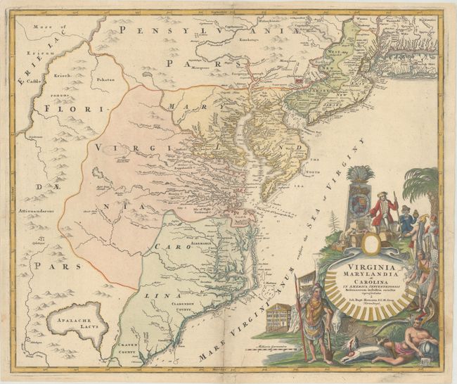
Auction 172, Lot 139
Subject: Colonial Mid-Atlantic United States
Homann, Johann Baptist
Virginia Marylandia et Carolina in America Septentrionali Britannorum Industria Excultae Repraesentatae, 1730
Size: 22.8 x 19.1 inches (57.9 x 48.5 cm)
Estimate: $1,600 - $2,000
Map Created to Promote German Immigration to the New World
Unsold
Closed on 4/17/2019
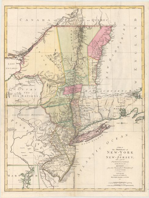
Auction 172, Lot 142
Subject: Colonial Mid-Atlantic United States
Lotter, Mathias Albrecht
A Map of the Provinces of New-York and New-Jersey, with a part of Pennsylvania and the Province of Quebec, from the Topographical Observations of C. J. Sauthier, 1777
Size: 22.3 x 29.5 inches (56.6 x 74.9 cm)
Estimate: $1,900 - $2,200
Important Revolutionary War Map
Sold for: $1,600
Closed on 4/17/2019
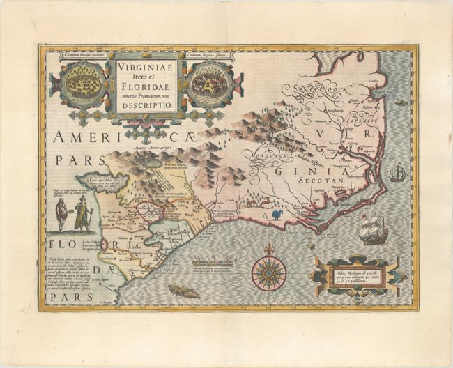
Auction 172, Lot 147
Subject: Colonial Southeast United States
Hondius, Jodocus
Virginiae Item et Floridae Americae Provinciarum, Nova Descriptio, 1619
Size: 19.3 x 13.6 inches (49 x 34.5 cm)
Estimate: $2,000 - $2,400
A Seminal Map of the Southeast and Early American Cartography
Sold for: $1,500
Closed on 4/17/2019
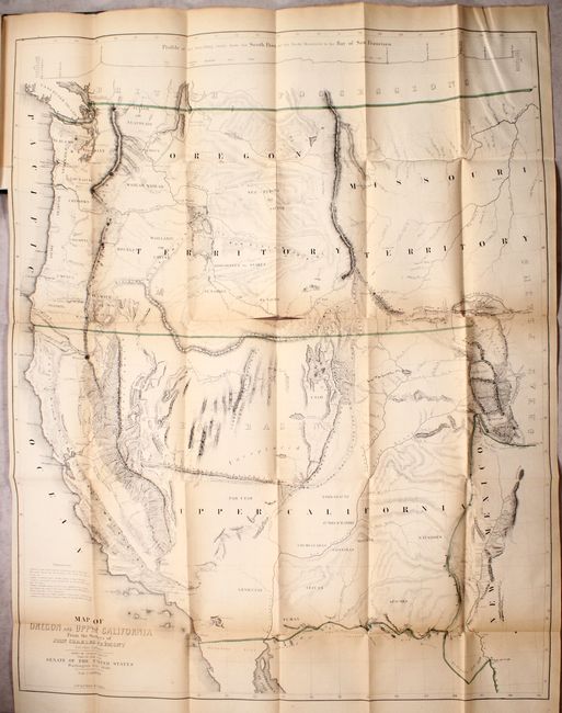
Auction 172, Lot 168
Subject: Western United States
Fremont/Preuss
Map of Oregon and Upper California from the Surveys of John Charles Fremont and Other Authorities [bound in] Geographical Memoir upon Upper California..., 1848
Size: 26.5 x 33 inches (67.3 x 83.8 cm)
Estimate: $1,600 - $1,900
Fremont's Map of the American West
Sold for: $850
Closed on 4/17/2019
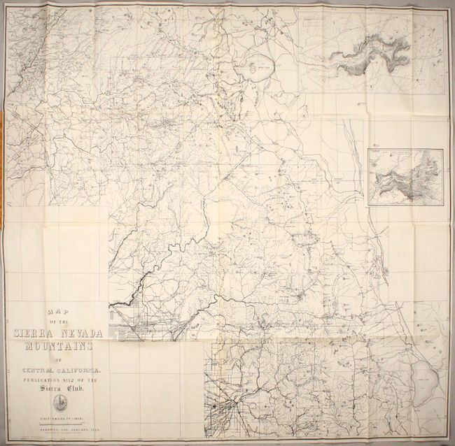
Auction 172, Lot 197
Subject: Central California, Yosemite
Map of the Sierra Nevada Mountains of Central California. Publication No. 12 of the Sierra Club, 1896
Size: 39.1 x 37.6 inches (99.3 x 95.5 cm)
Estimate: $700 - $850
A Scarce Sierra Club Map
Sold for: $500
Closed on 4/17/2019
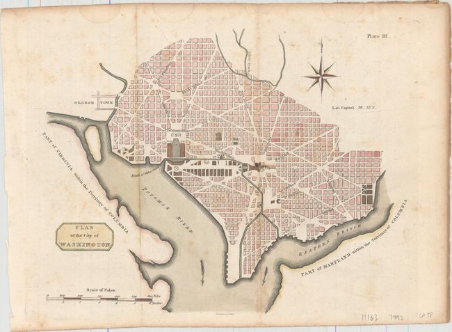
Auction 172, Lot 209
Subject: Washington, D.C.
Plan of the City of Washington, 1805
Size: 10.6 x 8.3 inches (26.9 x 21.1 cm)
Estimate: $1,200 - $1,500
Rare Scottish Plan of Washington
Unsold
Closed on 4/17/2019
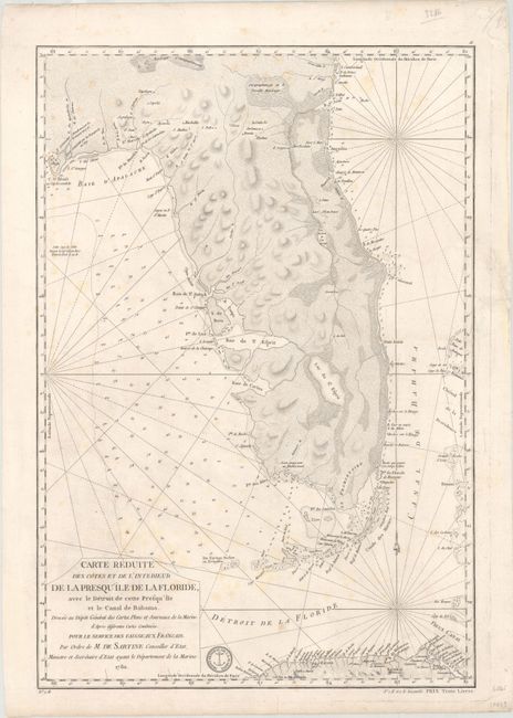
Auction 172, Lot 213
Subject: Florida
Sartine
Carte Reduite des Cotes et de l'Interieur de la Presqu'ile de la Floride, avec le Detroit de Cette Presqu'ile et le Canal de Bahama..., 1780
Size: 15.7 x 22.9 inches (39.9 x 58.2 cm)
Estimate: $2,000 - $2,300
Map of Florida Peninsula Intended for Use by French Navy During American Revolution
Sold for: $1,100
Closed on 4/17/2019
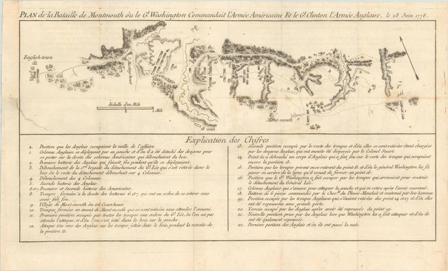
Auction 172, Lot 242
Subject: Monmouth, New Jersey
Plan de la Bataille de Montmouth ou le Gl. Washington Commandait l'Armee Americaine et le Gl. Clinton l'Armee Anglaise, le 28 Juin 1778, 1782
Size: 15.4 x 8.1 inches (39.1 x 20.6 cm)
Estimate: $1,200 - $1,500
An Important Battle Plan of the American Revolution
Unsold
Closed on 4/17/2019
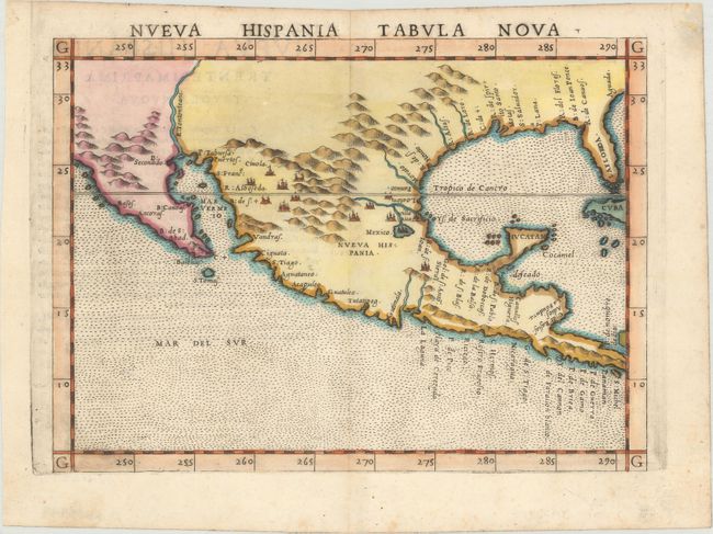
Auction 172, Lot 282
Subject: Southern United States & Mexico
Ruscelli, Girolamo
Nueva Hispania Tabula Nova, 1574
Size: 9.6 x 7.1 inches (24.4 x 18 cm)
Estimate: $1,300 - $1,600
A Foundation Map for the American Southwest
Sold for: $650
Closed on 4/17/2019
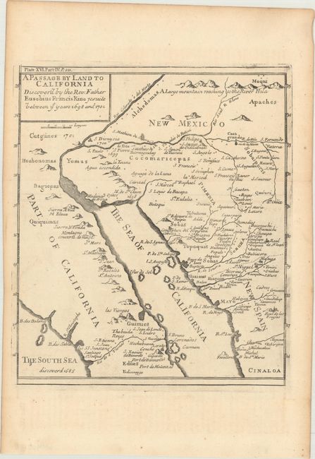
Auction 172, Lot 286
Subject: Southwestern United States & Mexico
Kino, Eusebio Francisco, SJ
A Passage by Land to California Discover'd by the Rev. Father Eusebius Francis Kino Jesuite Between ye Years 1698 and 1701 [with text], 1721
Size: 8 x 9.1 inches (20.3 x 23.1 cm)
Estimate: $950 - $1,200
Father Kino's Important Map of California
Sold for: $700
Closed on 4/17/2019
17 lots