Showing Featured Lots(remove filter)
Filtered by Category:United States(Show All Categories)
Showing results for:Auction 170
Catalog Archive
20 lots
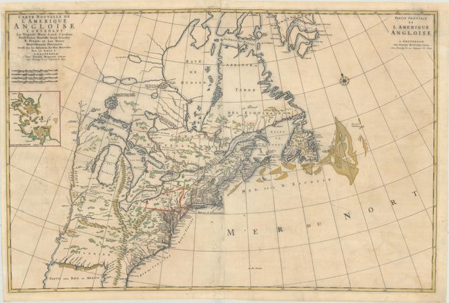
Auction 170, Lot 126
Subject: Colonial Eastern United States & Canada
Mortier, Pierre
Carte Nouvelle de l'Amerique Angloise Contenant la Virginie, Mary-Land, Caroline, Pensylvania Nouvelle Iorck. N: Iarsey N: France, et les Terres Nouvellement Decouerte..., 1700
Size: 35.4 x 23.4 inches (89.9 x 59.4 cm)
Estimate: $1,900 - $2,200
A Map Showing Fascinating Geographic Misconceptions
Unsold
Closed on 11/14/2018
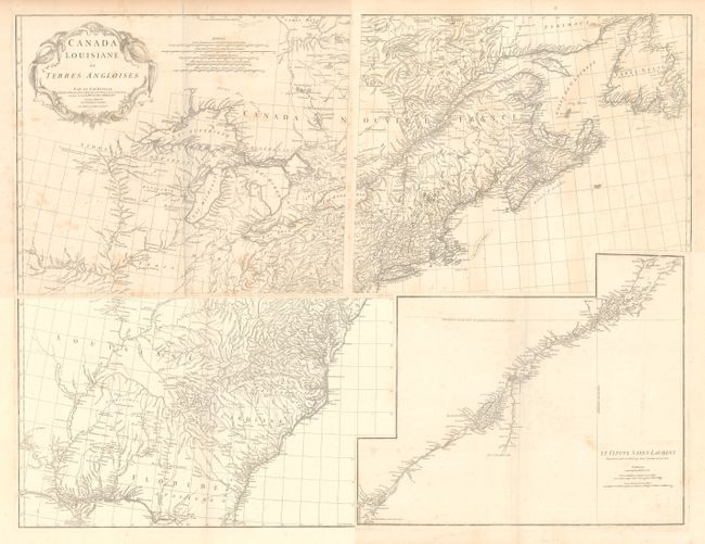
Auction 170, Lot 128
Subject: Colonial Eastern United States & Canada
Anville, Jean Baptiste Bourguignon d'
[On 4 Sheets] Canada Louisiane et Terres Angloises, 1755
Size: 22 x 18.8 inches (55.9 x 47.8 cm)
Estimate: $1,400 - $1,700
D'Anville's Spectacular Map of Eastern Seaboard
Unsold
Closed on 11/14/2018
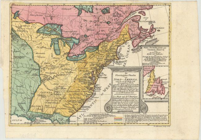
Auction 170, Lot 131
Subject: Colonial Eastern United States & Canada
Sotzmann, Daniel Friedrich
Die Vereinigten Staaten von Nord-America. Nach der von Wm. Faden 1783 herausgegebenen Charte / Les Etats Unis de l'Amerique Septentrionale d'Apres la Carte de Wm. Faden Publiee a Londres en 1783..., 1785
Size: 10 x 7.6 inches (25.4 x 19.3 cm)
Estimate: $600 - $800
Rare, Multi-Lingual Reduced Version of Faden's Map of 1783
Sold for: $550
Closed on 11/14/2018
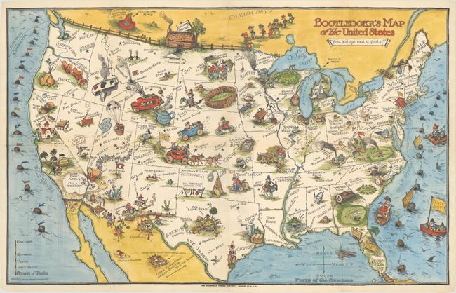
Auction 170, Lot 154
Subject: United States
Bootlegger's Map of the United States, 1931
Size: 33.9 x 21.4 inches (86.1 x 54.4 cm)
Estimate: $1,200 - $1,500
McCandlish's Humorous Prohibition Map in Hand Color
Sold for: $750
Closed on 11/14/2018
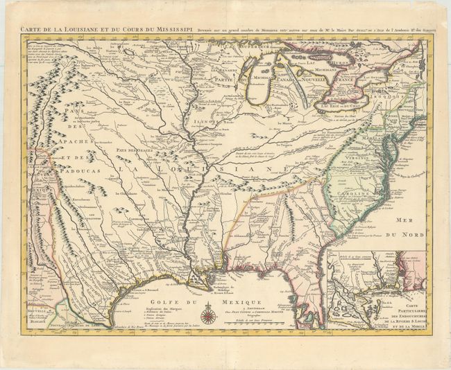
Auction 170, Lot 158
Subject: Colonial Eastern United States, Louisiana Territory
Delisle/Covens & Mortier
Carte de la Louisiane et du Cours du Mississipi Dressee sur un Grand Nombre de Memoires Entr'autres sur ceux de Mr. le Maire, 1730
Size: 23.4 x 17.3 inches (59.4 x 43.9 cm)
Estimate: $2,000 - $2,300
Delisle's Influential Map of the Louisiana Territory
Unsold
Closed on 11/14/2018
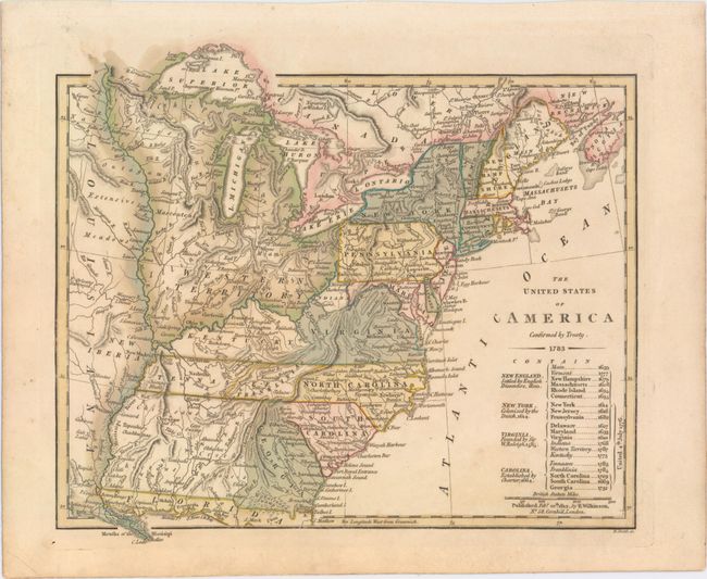
Auction 170, Lot 160
Subject: Eastern United States, Franklin
Wilkinson, Robert
The United States of America Confirmed by Treaty. 1783, 1812
Size: 11.3 x 9.8 inches (28.7 x 24.9 cm)
Estimate: $900 - $1,100
Early Map of the United States Featuring Franklinia and the Indiana Land Company
Sold for: $600
Closed on 11/14/2018
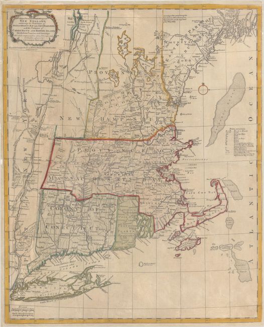
Auction 170, Lot 169
Subject: Colonial New England United States
Bowles, Carrington
A Map of the Most Inhabited Part of New England, Containing the Provinces of Massachusets Bay and New Hampshire, with the Colonies of Conecticut and Rhode Island..., 1771
Size: 20.4 x 25.1 inches (51.8 x 63.8 cm)
Estimate: $3,000 - $4,000
Reduced-Size Edition of Jefferys' Influential Map of New England
Sold for: $1,500
Closed on 11/14/2018
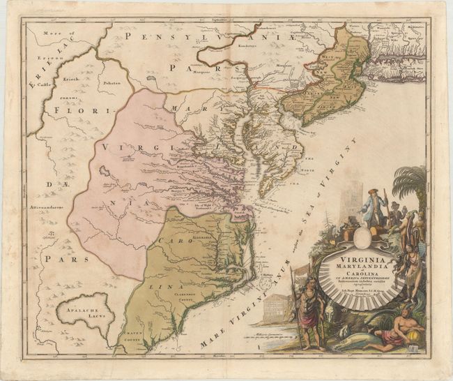
Auction 170, Lot 173
Subject: Colonial Mid-Atlantic United States
Homann, Johann Baptist
Virginia Marylandia et Carolina in America Septentrionali Britannorum Industria Excultae Repraesentatae, 1730
Size: 22.9 x 19.2 inches (58.2 x 48.8 cm)
Estimate: $1,600 - $2,000
Map Created to Promote German Immigration to the New World
Sold for: $1,200
Closed on 11/14/2018
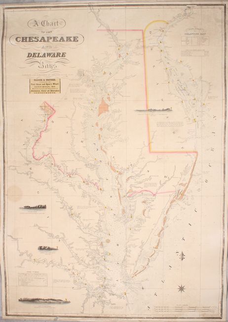
Auction 170, Lot 179
Subject: Mid-Atlantic United States, Chesapeake & Delaware Bays
Lucas, Fielding
A Chart of the Chesapeake and Delaware Bays, 1852
Size: 28.1 x 40.3 inches (71.4 x 102.4 cm)
Estimate: $5,500 - $7,000
Scarce Sea Chart of the Chesapeake and Delaware Bays
Unsold
Closed on 11/14/2018
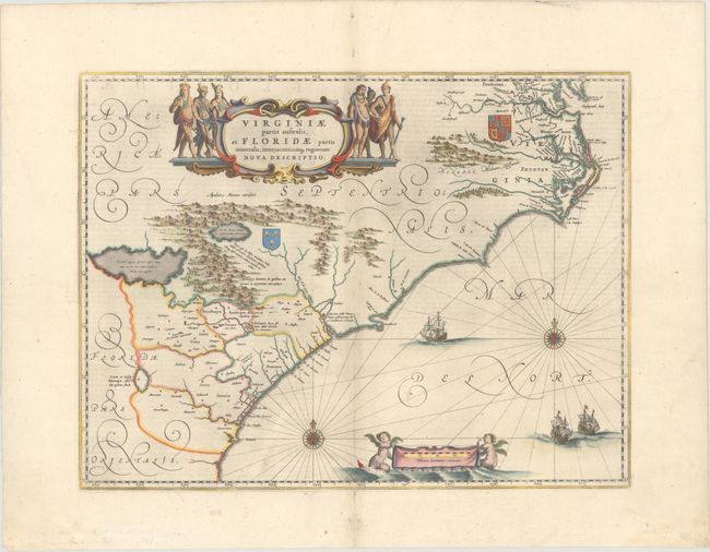
Auction 170, Lot 181
Subject: Colonial Southeast United States
Blaeu, Willem
Virginiae Partis Australis, et Floridae Partis Orientalis, Interjacentiumq Regionum Nova Descriptio, 1642
Size: 19.9 x 15.1 inches (50.5 x 38.4 cm)
Estimate: $1,100 - $1,400
Blaeu's Decorative Map of the Southeast
Sold for: $800
Closed on 11/14/2018
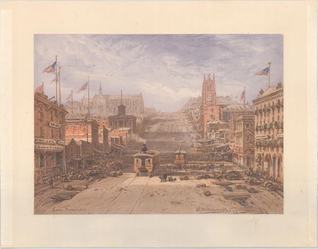
Auction 170, Lot 236
Subject: San Francisco, California
Hildebrandt, E.
San Francisco, 1864
Size: 15 x 10.8 inches (38.1 x 27.4 cm)
Estimate: $1,000 - $1,300
Lovely Chromolithograph of California Street in San Francisco
Sold for: $500
Closed on 11/14/2018
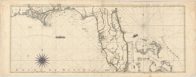
Auction 170, Lot 248
Subject: Florida
Le Rouge, George Louis
Carte de la Floride Occidentale et Louisiane / La Peninsule et Golfe de la Floride ou Canal de Bahama avec les Isles de Bahama, 1777
Size: 47.2 x 18.2 inches (119.9 x 46.2 cm)
Estimate: $1,800 - $2,100
Important Map of Florida and Its Coastlines
Sold for: $1,200
Closed on 11/14/2018
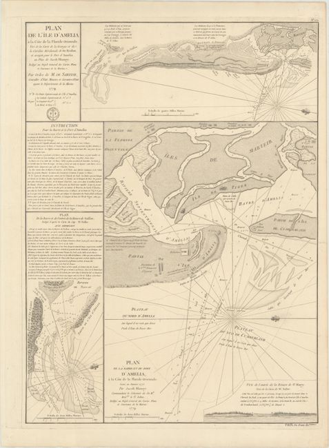
Auction 170, Lot 256
Subject: Amelia Island, Florida
Depot de la Marine
Plan de l'Ile d'Amelia... [on sheet with] Plan de la Barre et du Port d'Amelia... [and] Plan de la Barre et de l'Entree de la Riviere de Nassau..., 1779
Size: 17.1 x 23.3 inches (43.4 x 59.2 cm)
Estimate: $800 - $950
Issued for Use by the French Navy during the American Revolution
Sold for: $550
Closed on 11/14/2018
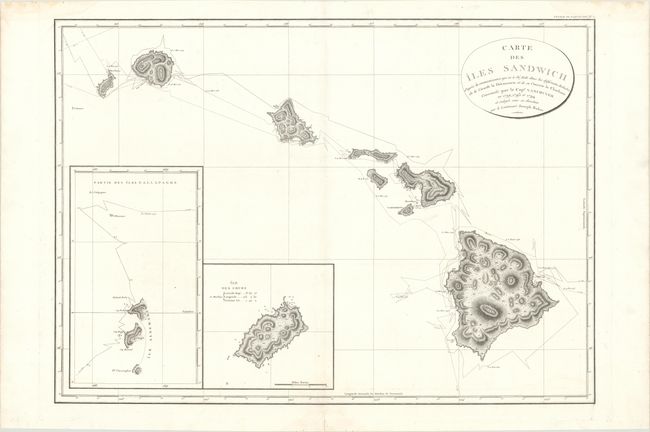
Auction 170, Lot 259
Subject: Hawaii
Vancouver, George (Capt)
Carte des Iles Sandwich d'Apres la Reconnoissance qui en a ete Faite dans les Differentes Relaches de la Corvelle la Decouverte et de sa Conserve le Chatham..., 1799
Size: 30.2 x 21.6 inches (76.7 x 54.9 cm)
Estimate: $1,400 - $1,700
Vancouver's Large Chart of Hawaii
Sold for: $700
Closed on 11/14/2018
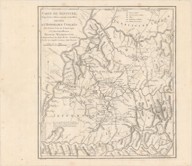
Auction 170, Lot 267
Subject: Kentucky
Filson, John
Carte de Kentucke, d'Apres les Observations Actuelles; Dediee a l'Honorable Congres des Etas-Unis de l'Amerique et a Son Excellence George Washington... [with] [2 Volumes] Lettres d'un Cultivateur Americain..., 1784
Size: 12.4 x 13.7 inches (31.5 x 34.8 cm)
Estimate: $2,400 - $3,000
The First Map of Kentucky
Sold for: $1,200
Closed on 11/14/2018
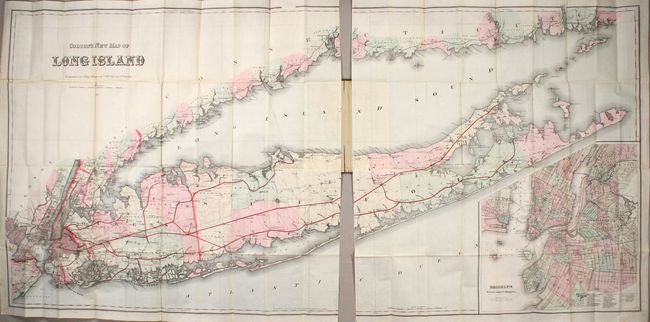
Auction 170, Lot 291
Subject: Long Island, New York
Colton, G.W. & C.B.
Colton's New Map of Long Island, 1886
Size: 64 x 30 inches (162.6 x 76.2 cm)
Estimate: $3,500 - $4,250
Monumental Map of Long Island in Mint Condition
Unsold
Closed on 11/14/2018
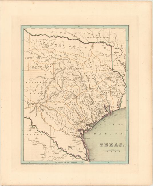
Auction 170, Lot 308
Subject: Texas
Bradford, Thomas Gamaliel
Texas, 1838
Size: 11.2 x 14.3 inches (28.4 x 36.3 cm)
Estimate: $2,000 - $2,400
Bradford's Republic of Texas
Sold for: $3,000
Closed on 11/14/2018
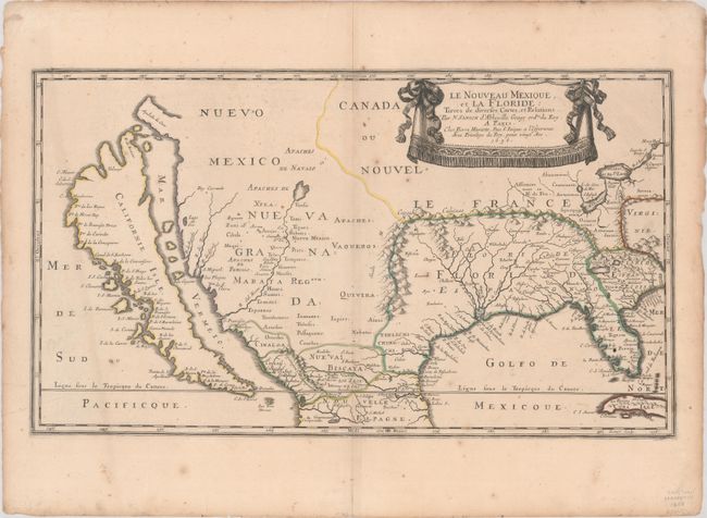
Auction 170, Lot 328
Subject: Colonial United States & Mexico
Sanson/Mariette
Le Nouveau Mexique, et la Floride: Tirees de Diverses Cartes, et Relations, 1656
Size: 21.4 x 12.2 inches (54.4 x 31 cm)
Estimate: $5,500 - $7,000
First Edition of Sanson's Important Map of the American Southwest
Sold for: $4,000
Closed on 11/14/2018
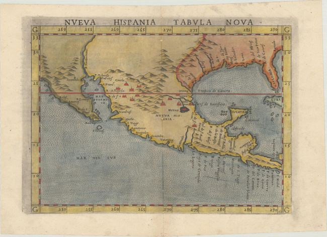
Auction 170, Lot 330
Subject: Southern United States & Mexico
Ruscelli, Girolamo
Nueva Hispania Tabula Nova, 1561
Size: 9.6 x 7 inches (24.4 x 17.8 cm)
Estimate: $1,300 - $1,600
A Foundation Map for the American Southwest
Sold for: $1,100
Closed on 11/14/2018
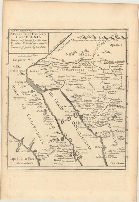
Auction 170, Lot 335
Subject: Southwestern United States & Mexico
Kino, Eusebio Francisco, SJ
A Passage by Land to California Discover'd by the Rev. Father Eusebius Francis Kino Jesuite Between ye Years 1698 and 1701 [with text], 1721
Size: 8 x 9.1 inches (20.3 x 23.1 cm)
Estimate: $1,000 - $1,300
Father Kino's Important Map of California
Unsold
Closed on 11/14/2018
20 lots