Showing Featured Lots(remove filter)
Filtered by Category:United States(Show All Categories)
Showing results for:Auction 100
Catalog Archive
28 lots
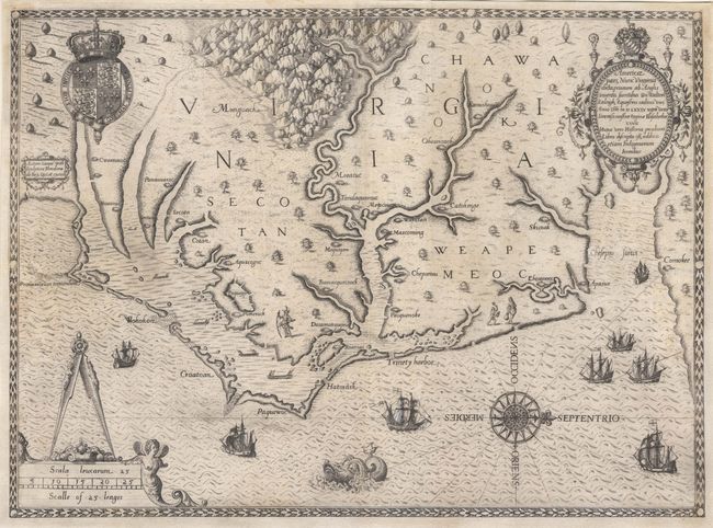
Auction 100, Lot 102
Subject: Colonial Southeast
White/De Bry
Americae pars, Nunc Virginia dicta, primum ab Anglis inuenta sumtibus Dn. Walteri Raleigh, Equestris ordinis Viri, 1590
Size: 16.2 x 16.7 inches (41.1 x 42.4 cm)
Estimate: $15,000 - $17,000
Sold for: $12,000
Closed on 9/12/2002
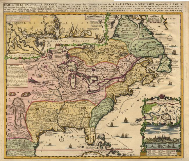
Auction 100, Lot 103
Subject: Colonial North America
Chatelain, Henry Abraham
Carte de la Nouvelle France, ou se voit le cours des Grandes Rivieres de S. Laurens & de Mississipi Aujour d'hui S. Louis, Aux Environs des-quelles se trouvent les Etats, Pais, Nations, Peuples &c., 1719
Size: 19 x 16.5 inches (48.3 x 41.9 cm)
Estimate: $2,500 - $2,750
Sold for: $1,900
Closed on 9/12/2002
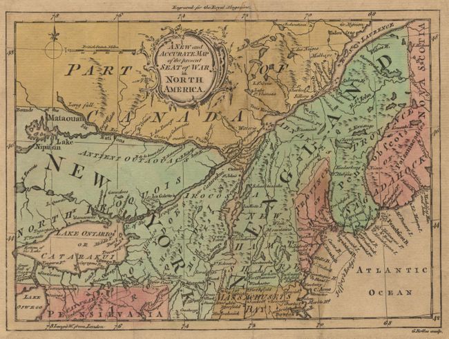
Auction 100, Lot 107
Subject: Colonial New England
Rollos, George
A New and Accurate Map of the present Seat of War in North America from a Late Survey, 1759
Size: 8.8 x 6.4 inches (22.4 x 16.3 cm)
Estimate: $230 - $275
Sold for: $275
Closed on 9/12/2002
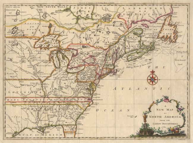
Auction 100, Lot 108
Subject: Colonial United States and Canada
Spilsbury, J.
A New Map of North America from the Latest Discoveries, 1761
Size: 14.8 x 10.8 inches (37.6 x 27.4 cm)
Estimate: $325 - $375
Sold for: $450
Closed on 9/12/2002
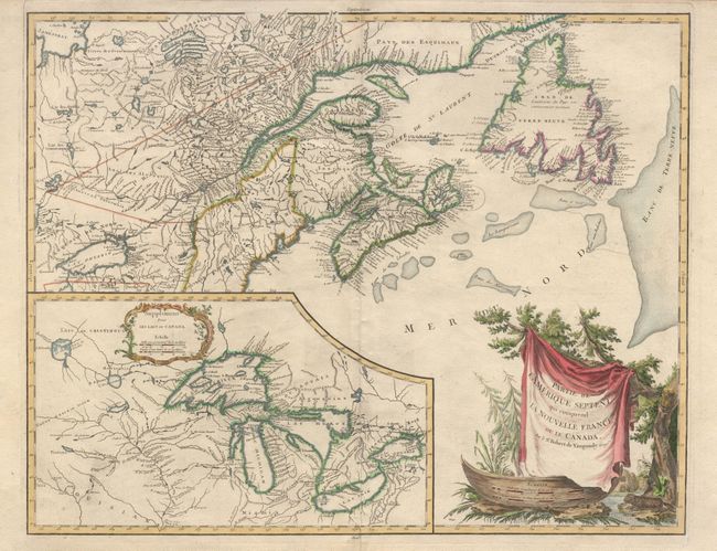
Auction 100, Lot 117
Subject: Colonial Canada - Great Lakes
Robert de Vaugondy, Didier
Partie de l'Amerique Septent? qui comprend la Nouvelle France ou le Canada, 1788
Size: 23.5 x 18.5 inches (59.7 x 47 cm)
Estimate: $800 - $900
Unsold
Closed on 9/12/2002
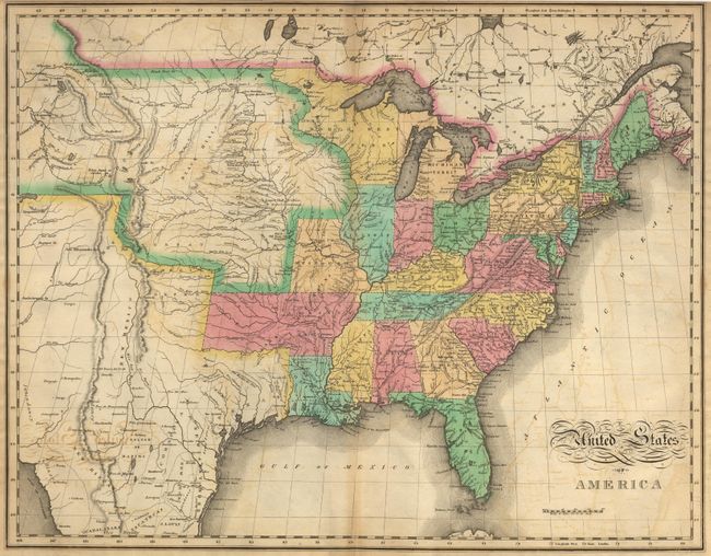
Auction 100, Lot 131
Subject: United States
Melish, John
United States of America…, 1821
Size: 21.5 x 17 inches (54.6 x 43.2 cm)
Estimate: $1,000 - $1,200
Sold for: $800
Closed on 9/12/2002
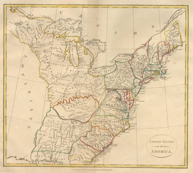
Auction 100, Lot 132
Subject: United States
Longman Co.
United States of America, 1808
Size: 15.5 x 13.5 inches (39.4 x 34.3 cm)
Estimate: $200 - $250
Sold for: $325
Closed on 9/12/2002
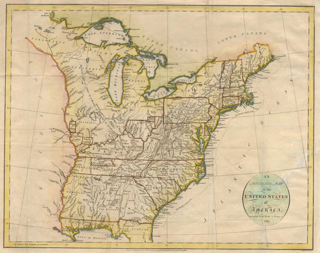
Auction 100, Lot 143
Subject: United States - Eastern
Russell, John C.
An Accurate Map of the United States of America according to the Treaty of Peace of 1783, 1794
Size: 18 x 14.2 inches (45.7 x 36.1 cm)
Estimate: $400 - $450
Sold for: $550
Closed on 9/12/2002
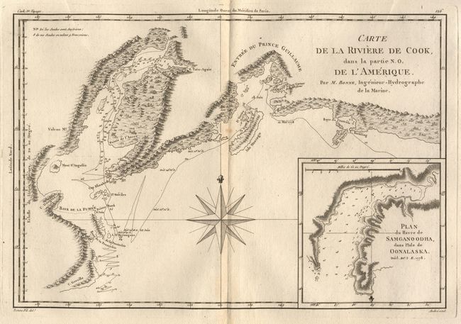
Auction 100, Lot 163
Subject: Alaska
Bonne, Rigobert
Carte de la Riviere de Cook dans la partie N.O. de l'Amerique, 1787-88
Size: 13.5 x 9.2 inches (34.3 x 23.4 cm)
Estimate: $90 - $120
Sold for: $150
Closed on 9/12/2002
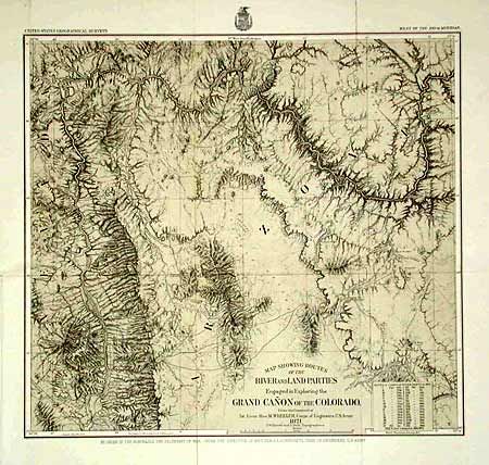
Auction 100, Lot 164
Subject: Arizona
Wheeler, George (Lt)
Map Showing Routes of the River and Land Parties Engaged in Exploring the Grand Canon of the Colorado, 1871
Size: 16.3 x 15 inches (41.4 x 38.1 cm)
Estimate: $200 - $250
Sold for: $275
Closed on 9/12/2002
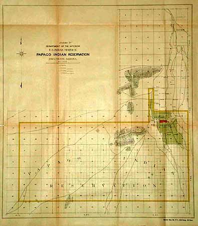
Auction 100, Lot 165
Subject: Arizona
U.S. Department of Interior
Papago Indian Reservation Pima County, Arizona, 1903
Size: 16.4 x 18 inches (41.7 x 45.7 cm)
Estimate: $120 - $150
Sold for: $80
Closed on 9/12/2002
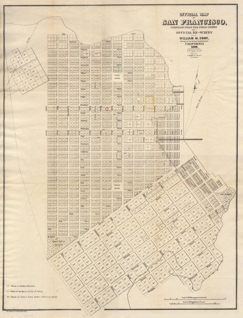
Auction 100, Lot 167
Subject: California
Eddy, William M.
Official Map of San Francisco, Compiled from the Field Notes of the Official Re-Survey…, 1849
Size: 19 x 24.8 inches (48.3 x 63 cm)
Estimate: $600 - $800
Sold for: $1,000
Closed on 9/12/2002
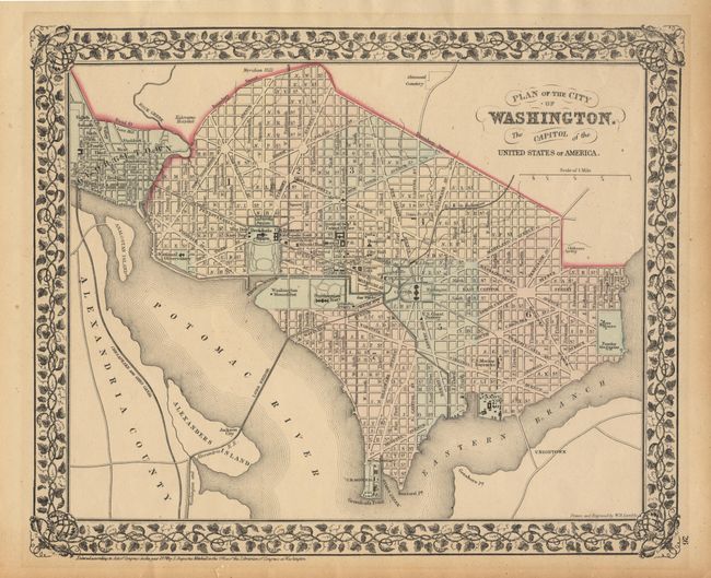
Auction 100, Lot 174
Subject: District of Columbia
Mitchell, Samuel Augustus
Plan of the City of Washington. The Capitol of the United States of America, 1874
Size: 10.8 x 13.2 inches (27.4 x 33.5 cm)
Estimate: $50 - $70
Sold for: $80
Closed on 9/12/2002
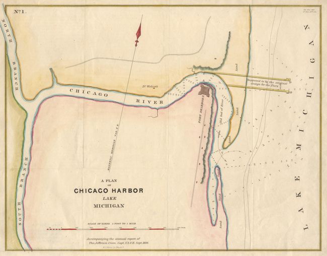
Auction 100, Lot 178
Subject: Illinois
Cram, Thomas Jefferson (Capt.)
A Plan of Chicago Harbor Lake Michigan, 1839
Size: 14.3 x 11 inches (36.3 x 27.9 cm)
Estimate: $100 - $130
Sold for: $350
Closed on 9/12/2002
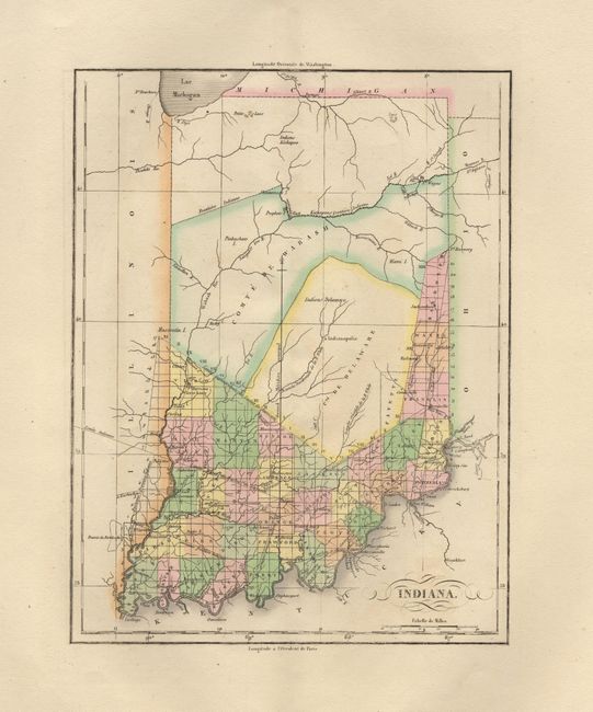
Auction 100, Lot 179
Subject: Indiana
Buchon, Jean Alexandre
Carte Geographique, Statistique et Historique de l'Indiana, 1825
Size: 8.5 x 11 inches (21.6 x 27.9 cm)
Estimate: $275 - $325
Sold for: $200
Closed on 9/12/2002
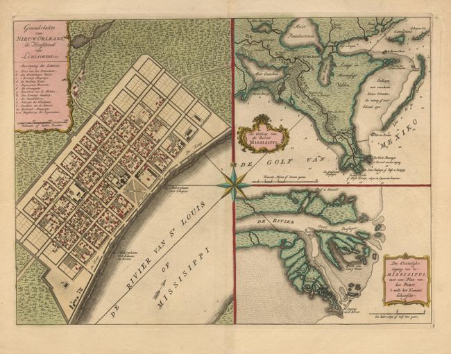
Auction 100, Lot 184
Subject: Louisiana, New Orleans
Tirion, Isaac
Grondvlakte van Nieuw Orleans, de Hoofdstad van Louisiana [on sheet with] De Uitloop van de Rivier Missisippi [and] De oostelyke Ingang van de Missisippi, met een Plan van het Fort, 't Welk het Kanaal Beheerscht, 1763
Size: 17.5 x 13 inches (44.5 x 33 cm)
Estimate: $800 - $850
Sold for: $850
Closed on 9/12/2002
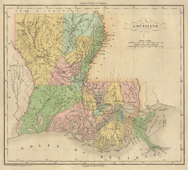
Auction 100, Lot 185
Subject: Louisiana
Buchon, Jean Alexandre
Carte Geographique, Statistique et Historique de la Louisiane, 1825
Size: 12.7 x 11.2 inches (32.3 x 28.4 cm)
Estimate: $275 - $325
Sold for: $210
Closed on 9/12/2002
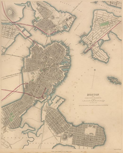
Auction 100, Lot 190
Subject: Massachusetts
SDUK Society for the Diffusion of Useful Knowledge
Boston with Charlestown and Roxbury, 1842
Size: 11.9 x 14.5 inches (30.2 x 36.8 cm)
Estimate: $150 - $200
Sold for: $160
Closed on 9/12/2002
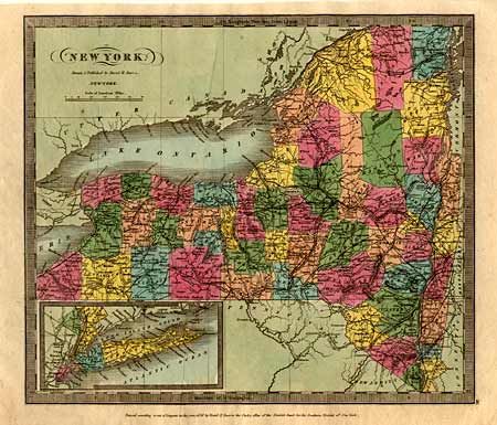
Auction 100, Lot 202
Subject: New York
Burr, David H.
New York, 1836
Size: 11.9 x 10.3 inches (30.2 x 26.2 cm)
Estimate: $120 - $150
Sold for: $80
Closed on 9/12/2002
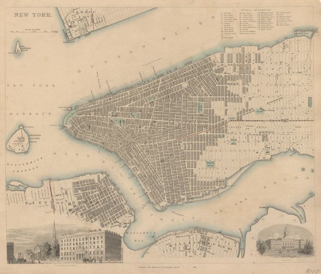
Auction 100, Lot 203
Subject: New York City
SDUK Society for the Diffusion of Useful Knowledge
New York, 1845
Size: 14.8 x 12 inches (37.6 x 30.5 cm)
Estimate: $150 - $200
Sold for: $180
Closed on 9/12/2002
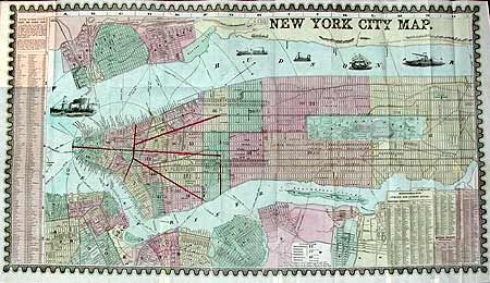
Auction 100, Lot 204
Subject: New York
Phelps, Humphrey
New York City Map, 1857
Size: 27.5 x 15 inches (69.9 x 38.1 cm)
Estimate: $300 - $400
Sold for: $400
Closed on 9/12/2002
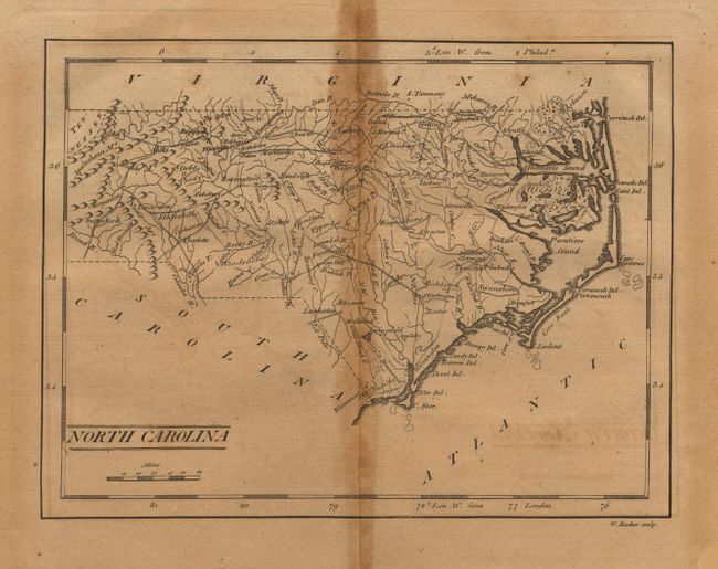
Auction 100, Lot 205
Subject: North Carolina
Anon.
[Lot of 2] A New and Accurate Map of North Carolina in North America [together with] North Carolina, 1800
Size: 14 x 10.5 inches (35.6 x 26.7 cm)
Estimate: $200 - $250
Sold for: $180
Closed on 9/12/2002
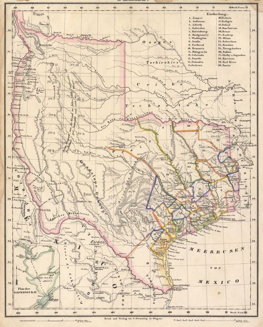
Auction 100, Lot 217
Subject: Texas
Flemming, Carl
Texas, 1853
Size: 12.5 x 15.5 inches (31.8 x 39.4 cm)
Estimate: $800 - $900
Sold for: $850
Closed on 9/12/2002
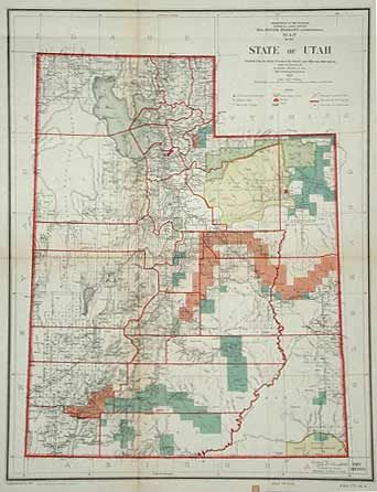
Auction 100, Lot 220
Subject: Utah
General Land Office
Map of the State of Utah, 1902
Size: 13 x 16.8 inches (33 x 42.7 cm)
Estimate: $80 - $100
Sold for: $100
Closed on 9/12/2002
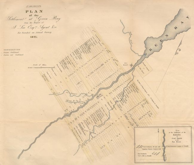
Auction 100, Lot 223
Subject: Wisconsin
U.S. Government
Plan of the Settlement at Green Bay from the Report of J. Lee Esq.re Agent &c Not founded on Actual Survey 1821, 1850
Size: 18 x 15 inches (45.7 x 38.1 cm)
Estimate: $200 - $230
Unsold
Closed on 9/12/2002
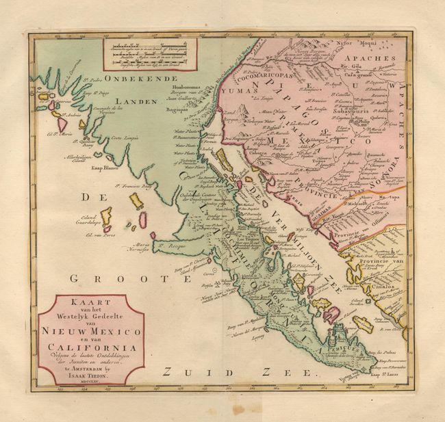
Auction 100, Lot 225
Subject: Southwestern United States & Mexico
Tirion, Isaac
Kaart van het Westelyk Gedeelte van Nieuw Mexico en van California…, 1765
Size: 13.5 x 12.7 inches (34.3 x 32.3 cm)
Estimate: $900 - $1,000
Sold for: $650
Closed on 9/12/2002
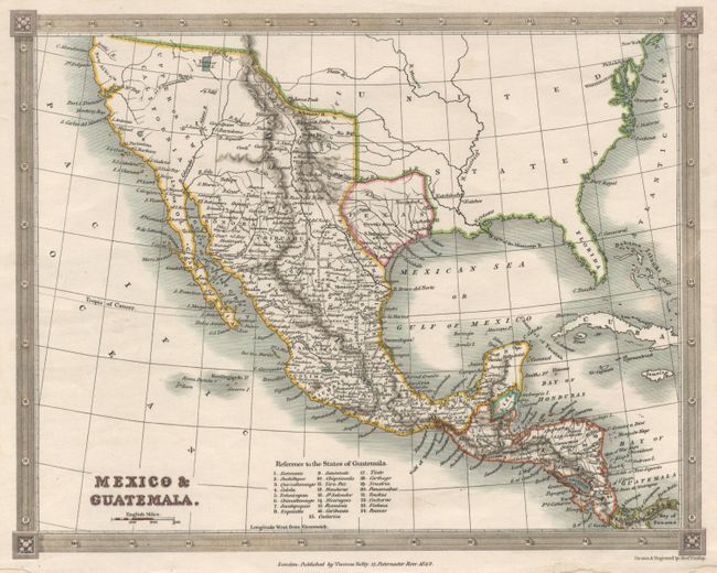
Auction 100, Lot 229
Subject: Southern United States, Mexico and Central America
Findlay, Alexander
Mexico & Guatemala, 1842
Size: 9.5 x 7.5 inches (24.1 x 19.1 cm)
Estimate: $150 - $180
Sold for: $140
Closed on 9/12/2002
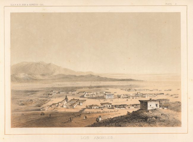
Auction 100, Lot 480
Subject: California
U.S. Railroad Surveys
Los Angeles, 1856
Size: 9.4 x 6.5 inches (23.9 x 16.5 cm)
Estimate: $160 - $180
Sold for: $170
Closed on 9/12/2002
28 lots