Subject: Colonial Southeast
Period: 1590 (circa)
Publication: Admiranda Narratio fida tamen, de Commodis et Incolarum Ritibus Virginiae
Color: Black & White
Size:
16.2 x 16.7 inches
41.1 x 42.4 cm
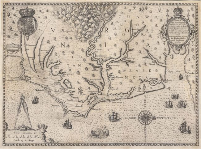
This map of Virginia and North Carolina is one of the most significant milestones in cartographic history of North America. It is the earliest collectible map of the region and the earliest map to show and name the Chesapeake Bay (Chesepiooc Sinus). Based directly on the manuscript map by John White, governor of the Roanoke colony, the map records the first English attempts at colonization in the New World. The map's influence can be seen in virtually every map of Colonial North America for the succeeding 100 years. It covers the area from Chesapeake Bay to Cape Lookout, locating numerous Indian villages. The map is also a masterful engraving adorned with the Royal Arms of England, English ships sailing in the Outer Banks, Indian canoes around the Albemarle and Pamlico Sounds, Indian figures, a large compass rose, sea monster, and two decorative cartouches. This example appears to be the second state according to Burden with the village name Chesepiooc with a "C" correcting the original plate's "E". However, the "E" is very faint and this may be the rarer third state.
References: Burden #76; Cumming #12; Lorant, pp. 274,275; Schwartz & Ehrenberg, plt. 37.
Condition: A
This map has been very skillfully restored with paper-cast to restore margins and expert facsimile of bottom border. Backed with light Japanese tissue.