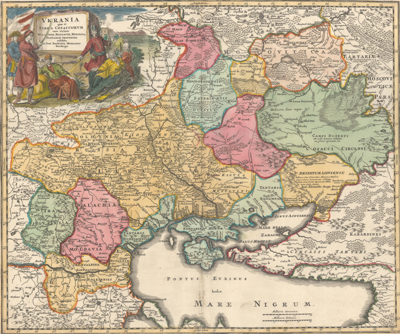
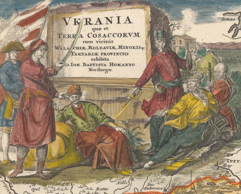
Johann Baptist Homann’s Ukrania quae et Terra Cosaccorum, 1716.
The Heart of Ukraine in Early Maps
by Eliane Dotson
[Click on any image in this article for more information on the map, and in most cases a zoomable image of the map.]
The territory of modern Ukraine has long been a contested region, divided among neighboring powers eager to increase their territorial wealth. During the Middle Ages, parts of the region belonged at different times to the Khazar state, the Mongol Golden Horde, Kievan Rus’ (also known as Ruthenia), Galicia Volhynia, and the Grand Duchy of Lithuania, among others. After the Union of Lublin in 1569, the majority of Ukraine fell under the Polish–Lithuanian Commonwealth (also known as the Kingdom of Poland and the Grand Duchy of Lithuania), while some eastern parts were under Russian rule. Polish people began moving into Ukraine, and many Ukrainians became Polonized and converted to Catholicism, particularly among the nobility. Ruthenian peasants, who were primarily East Slavic people, remained Eastern Orthodox, and this religious divide caused tensions. The Polish and Polonized Ukrainians began forcing Ruthenians into serfdom, causing the Ruthenians to join with the Cossacks who inhabited areas around the Dnieper River.
Beginning in the Middle Ages, various Cossack hosts (or groups) inhabited areas around the Dnieper, Don, Volga and Ural Rivers, as well as regions in the Caucasus. The Cossacks were predominantly East Slavic Orthodox and maintained self-governing communities with military forces. Different areas in the region were governed by a Cossack host, and each host developed a name, such as the Zaporozhian Cossacks, who lived along the lower Dnieper, and the Don Cossacks, who settled along the Don River. The Cossacks were known to protect their territory and their independence and alternated between having alliances and conflicts with surrounding powers, such as the Ottoman Empire, and later the Polish-Lithuanian Commonwealth and the Tsardom of Russia, as well as neighboring Cossack hosts. The Zaporozhian Cossacks grew in population during the period of the Polish–Lithuanian Commonwealth. Due to tensions with the Polish people and their government, the Zaporozhian Cossacks began revolting against the Commonwealth in a series of uprisings. In 1648, the Zaporozhian Cossacks established their independence as the Cossack Hetmanate, occupying most of central Ukraine. Although the Cossack Hetmanate maintained autonomy for over a century, it was under a treaty of protection with Russia. Over time, Russia’s protection evolved into Russian rule. After the Partitions of Poland in 1772, 1793 and 1795, the far western portion of Ukraine, including the city of Lviv, came under rule of the Austro-Hungarian Empire, while the remainder became part of the Russian Empire.
The majority of Ukraine remained under Russian rule until the Ukrainian War of Independence (1917-21), which created the Ukrainian People’s Republic. The new country experienced internal political strife and was short-lived, becoming the Ukrainian Soviet Socialist Republic and a founding member of the Soviet Union in 1922. The Ukrainian people suffered several devastating famines under Soviet rule, as well as great loss of life during World War II. As millions of Ukrainian people died, Russians immigrated into Ukraine to fill their places. After the collapse of the Soviet Union in 1991, Ukraine regained independence, however division along regional and ethnic lines continued. In 2014, Russia invaded and subsequently annexed Crimea, spurring unrest in eastern and southern Ukraine. In February 2022, Russia invaded Ukraine.
And thus Ukraine as a country is a relatively new concept, and the mapping of Ukraine must be explained as a mapping of a region, split into territories under separate rule. The region was divided and redivided many times over the centuries, adding complexity to the cartographic history of the region. And yet the European mapping of Ukraine can be separated into three distinct stages. The first was the early mapping of the Renaissance period, which relied heavily on ancient sources. The second stage began in the 17th century, after surveys of the land had been conducted, improving the accuracy of maps of the region. And the third stage began while the region was primarily under Russian rule, around the turn of the 18th century. In each of these stages, political boundaries were ever shifting and nomenclature was updated to reflect better knowledge of the region and the prevailing powers.
STAGE 1: MAPPING BASED ON THE ANCIENTS
European maps of the late 16th – 17th centuries that included the Ukraine focused on the larger regions of Eastern Europe or Russia and the Caucasus. These maps relied heavily on ancient sources such as Ptolemy, updated with regional names from the Middle Ages.
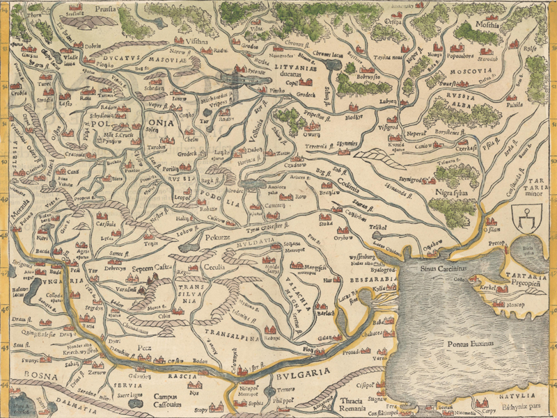
Sebastian Munster’s modern map of Poland and Hungary gives an imprecise view of the river systems, with the Dnieper River called Neper Fl. and Borystenes Fl. The city of Kyovia (Kyiv) can be found along the Dnieper. Regions within present-day Ukraine are called Russia (Rus or Ruthenia), Podolia (Podillia), Volhinia (Volhynia), Tartaria Minor, and Tartaria Precopien (Crimea). The emblem of the Golden Horde is at far right, indicating the region controlled by the Crimean Khanate.
Sebastian Munster, Poloniae et Ungariae Nova Descriptio, 1552.
Gerard Mercator’s map of the region north of the Black Sea, including Crimea, divides the Ukraine into Podolia, Lithuaniae Pars, Russiae Pars, Crimea seu Tartaria Przecopensis, and Taurica Chersonesus.
Gerard Mercator, Taurica Chersonesus Nostra Aetate Przecopsca et Gazara Dicitur, 1619
STAGE 2: MAPPING BASED ON NEW SURVEYS
After the Polish-Lithuanian Commonwealth gained control of most of Ukraine, understanding the geography of the region became a priority, and two important surveys were commissioned. These surveys culminated in several important maps that would influence the cartography of the region for over a century. The first was initiated by Crown Prince Nicholas Christopher Radziwill and is typically attributed to Tomasz Makowski, although the first printed edition was engraved by Hessel Gerritsz and published by Willem Blaeu.
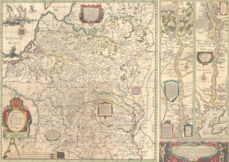
Initially issued as a wall map in 1613 and then included in Blaeu’s atlases beginning in 1631, Magni Ducatus Lithuaniae, was the first published map to include the name “Ukraina.” It greatly improved upon the mapping of the region with the addition of new settlements and updates to the river systems. The region west of Kiova (Kyiv) is called Volynia Ulterior, quae tum Ukraina tum nis ab aliis volcitatur. The map also included a large inset following the course of the Dnieper River from Cherkasy to the estuary on the Black Sea, featuring a cartouche describing the Cossacks in the region and their settlements.
Willem Blaeu, Magni Ducatur Lithuaniae…, 1641.
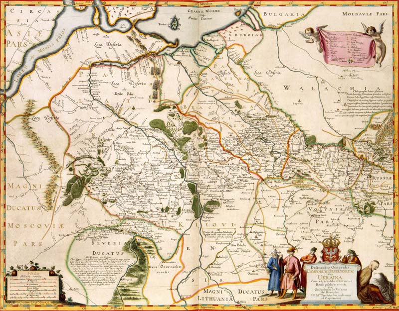
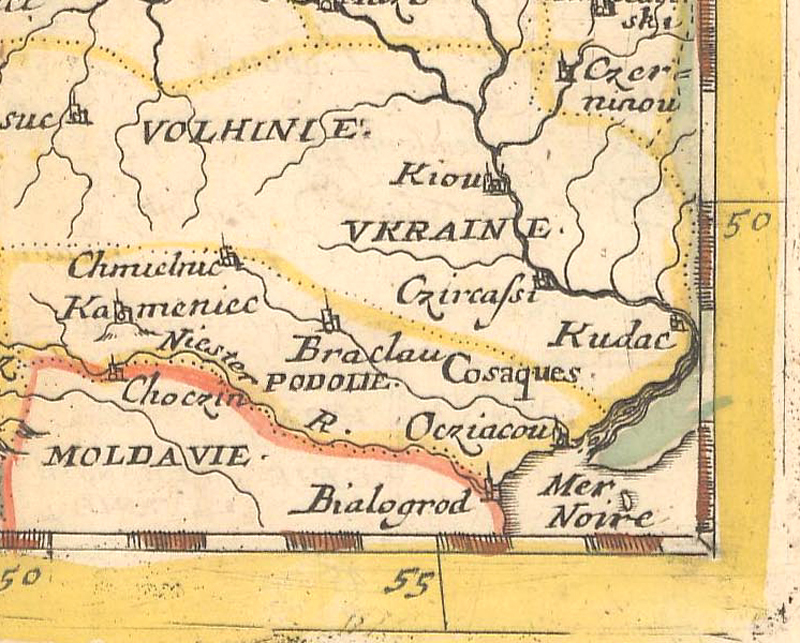
The second major survey was conducted by Frenchman Guillaume le Vasseur de Beauplan on behalf of King Ladislaus IV of Poland. The king wanted to understand the land and its people in order to protect the territory from enemies (particularly the Tsardom of Russia). Beauplan published several maps of the region beginning in 1648, as well as a written account of the geography of the region and the customs and habits of the Cossacks, first issued in 1651. His single-sheet Delineatio generalis Camporum Desertorum vulgo Ukraina (1648) and his 8-sheet Delineato Specialis et Accurata Ukrainae (1650) were both engraved by Willem Hondius. In these maps, Ukraine is divided into Palatinatus Kiioviensis, Palatinatus Braclaviensis, Podolia, Volyniae Pars, and Russiae Pars. Beauplan’s work greatly influenced European cartographers, including Nicolas Sanson and Willem Blaeu, who based his set of 4 regional maps of Ukraine (Ukrainae Pars…) on Beauplan’s maps, each featuring cartouches with images of Cossacks.
Guillaume Le Vasseur de Beauplan, Delineatio generalis Camporum Desertorum vulgo Ukraina: cum adjacentibus Provinciis, 1648. Map image courtesy of the Koninklijke Bibliotheek in the Netherlands.
Between 1660-1770, the majority of European maps of the region included references to either Ukraine, the Cossacks, or both.
Pierre Duval, Pologne, 1661. The region of “Ukraine” is shown along the Dnieper and “Cosaques” is included near the banks of the Black Sea.
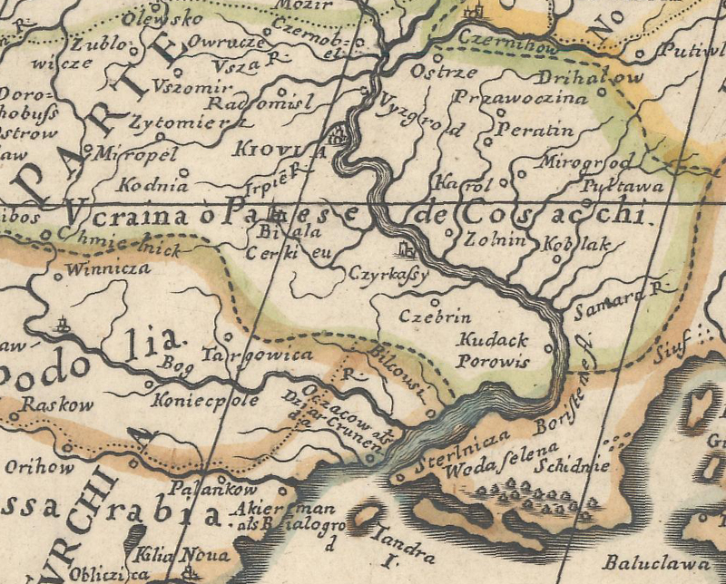
Giamcomo Giovanni Rossi, Russia Bianca o Moscovia…, 1678. The region of “Ucraina o Paese de Cosacchi” straddles the Dnieper River and is part of Poland.
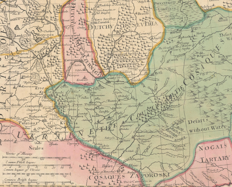
John Senex, Moscovy Corrected from ye Observations…, 1712. “Ukraine the county of the Cosaques” stretches across parts of Poland and Russia, with “Cosaques Zaporoski” noted to the south.
Johann Baptist Homann, Ukrania quae et Terra Cosaccorum, 1716: The title translates as “Ukraine the Land of the Cossacks” and depicts the Cossacks’ struggle for independence.
STAGE 3: MAPPING UNDER TSARIST RULE
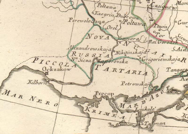
After the partitions of Poland and the division of Ukraine between the Austro-Hungarian Empire and the Russian Empire, the terms “Ukraine” and “Cossack” began to disappear from maps. Russia was eager to assert its dominance over the Ukraine and signal to Europe that this formerly “independent” territory was part of Russia. The term “New Russia” began appearing on maps in place of “Ukraine.”
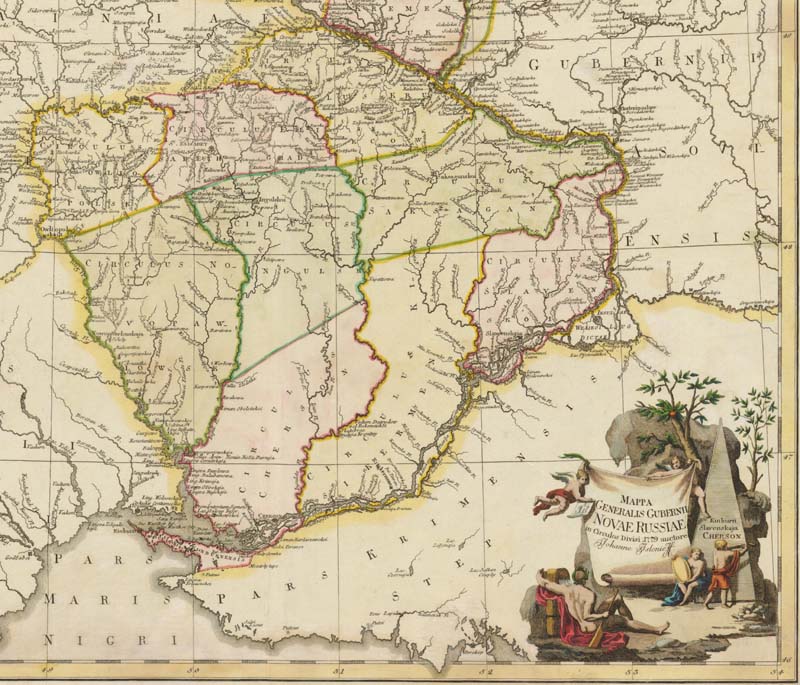
Ivan Islenyev, Mappa Generalis Gubernii Novae Russiae in Circulos Divisi, 1779. This map was prepared for Peter the Great’s survey and shows “Novae Russiae” (New Russia).
Antonio Zatta, La Russia Europea Divisa Ne’ Suoi Governi, e Provincie, 1781. The region west of the lower Dnieper River is named “Nova Russia.”
THE HEART OF UKRAINE
Although the boundaries of Ukraine have shifted many times over the centuries, the people of Ukraine – the Ruthenians, Cossacks, and others – have remained at the heart of the region. It is illuminating how the people of Ukraine became intertwined with its cartography during the second stage of European mapping of the region. It was only by force under Tsarist rule that these groups, and the notion of Ukraine itself, were erased from maps. But the people of Ukraine remained at the heart of their land, and although they may have been invisible to the outside world, they did not disappear. Ukrainians finally asserted their independence again at the end of World War I, and although the Ukrainian People’s Republic was quickly brought under Soviet rule, a few maps remain to remind us of this time. Ukraine has fought for its independence time and time again, creating a nation of strong people able to band together during times of adversity and fight for their land.
National Survey Co., The Official Map of the World, 1920. This map shows Ukraine as a separate country for its brief period of independence following World War I.
References:
Kordan, Bohdan S., The Mapping of Ukraine: European Cartography and Maps of Early Modern Ukraine, 1550-1799, The Ukrainian Museum, New York, 2008.
Nikolin, Vladimir, Ukraine on Old Maps End of 15th to First of 17th Century, 2006.
Nikolin, Vladimir, Ukraine on Old Maps from the Mid-17th to the Second Half of 18th C., 2009.
Prymak, Thomas M., [Book Review of Kordan’s The Mapping of Ukraine], Journal of Ukrainian Studies 33-34, 2008-2009.