Subject: District of Columbia
Period: 1820 (dated)
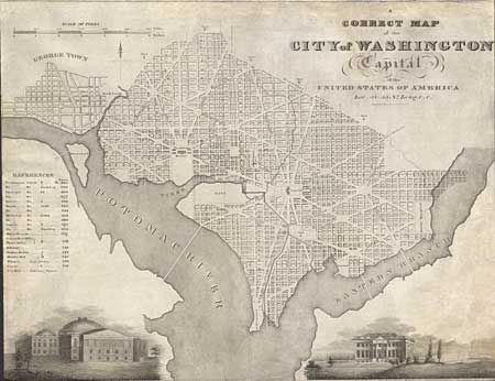
Publication: A National Calendar for 1820
Color: Black & White
Size:
21 x 16 inches
53.3 x 40.6 cm
Handsome plan of the city engraved by W.J. Stone and published by Peter Force. It provides good detail of city and includes two engraved vignettes: 'North Front of the President's House' and 'West Front of the Capital'. A table identifies the location of twenty important buildings and churches. Wards 1-6 are noted and the Mall is completely blank. Remarkable in that it is rather late to be printed on fine hand laid paper, particularly American-made paper with the large watermark of M & K, N York.
References: Phillips (M) pg. 1010; Phillips (Wash) p. 29.
Condition: B
Good impression. Trimmed to neatline with attribution to Peter Force and title 'North Front of the President's House just visible. Title to left vignette is trimmed away, apparently as issued.