Subject: Arizona
Period: 1877 (dated)
Publication:
Color: Black & White
Size:
24.1 x 34.5 inches
61.2 x 87.6 cm
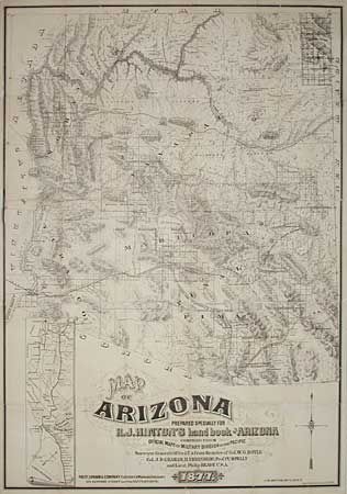
This is an extremely scarce large-scale map of Arizona Territory. Despite the title attribution, the map was issued before the book was published and is rarely included with the book. Lithographed by Britton, Rey & Co. and published by Paydt, Upham & Company of San Francisco in 1878. This extremely detailed map locates mining districts, the Indian reservations, towns, cities, counties, forts, camps, stage routes, landmarks, mountain ranges, creeks, rivers, mills, telegraph lines, etc. The line of the Atlantic and Pacific Railroad is shown with the grant lands marked 40 Mile Limits on either side of the route. The Southern Pacific follows the Overland Stage Route along the Gila River in western Arizona with its proposed route through Tucson and into the mining districts in the southern part of the territory. There is an inset map: "Map of the Southern Pacific Railroad Connecting with the Central Pacific R.R. at Goshen 1877". It depicts the rail line from San Francisco to Yuma and the stopping points along the way. There is a line in blue pencil along the Maricopa and Pima county borders, probably done by a previous owner. This map along with the Eckhoff and Riecker map of Arizona issued in 1880 are the finest large scale maps of Arizona Territory issued in the 19th century. We have never seen this map bound in Hinton's book and the major collections auctioned in the past decades have the map separate from the book.
References: Phillips (M) p. 123; Streeter Sale #525.
Condition: B
Some small areas of loss at fold intersections and in left margin. The map has been backed with a heavy Japanese tissue to strengthen the thin fragile paper. Areas of loss have been toned, but there is no facsimile.