Subject: United States
Period: 1849 (circa)
Publication: HR Ex Doc. 1, 30th Cong., 2nd Session
Color: Hand Color
Size:
33.2 x 13.6 inches
84.3 x 34.5 cm
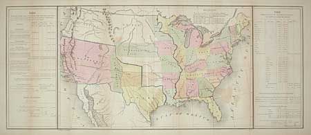
The Republic of Texas is shown with its northern boundary extending to 42 degrees N. latitude. A large California Territory extends nearly to Texas with a small New Mexico sandwiched in between. Interesting versions of treaty boundaries are drawn and a table of explanations provides treaty dates. Sometimes referred to as the 'Tables Map' because a table on each side of the map offers selected statistical information including details on the "Three Divisions" of Texas. Probably prepared for the General Land Office to show Guadeloupe-Hidalgo treaty lines (Wheat). Printed by Duval in Philadelphia and drawn by E. Gilman.
References: Koepp CIS 537; Wheat (TM) 561; Streeter Sale 3876.
Condition: B
Two light areas of offsetting and light toning along folds. Backed with Japanese tissue.