Catalog Archive
Auction 98, Lot 423

"Carte der Entdekungen Zwischen Sibirien und America bis auf das Jahr 1780", Anon.

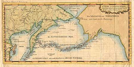
Subject: North Pacific - Arctic

Period: 1781 (circa)

Publication: Neue nordische Beyatrage

Color: Hand Color

Size:
16.2 x 7.7 inches
41.1 x 19.6 cm
Download High Resolution Image
(or just click on image to launch the Zoom viewer)

Very unusual map of Alaska and Kamchatka. Alaska is shown with only coastal detail according the the reports of Capt. Cook. The Aleutian Islands stretch to within sight of the Asia coastline. The Bering Strait is labled Cooks Stasse. There is more detail in the topography of Siberia and Kamchatka. The Arctic Ocean is rendered with icebergs.

References: Falk #1781-3.

Condition: B

Margins extended at both sides. Faint offsetting.

Estimate: $140 - $180

Sold for: $140

Closed on 3/6/2002

Archived