Subject: Colonial Mid Atlantic
Period: 1775 (published)
Publication:
Color: Hand Color
Size:
20.5 x 26.3 inches
52.1 x 66.8 cm
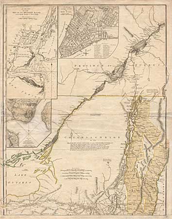
This is one sheet of a two-sheet map based on the surveys of Major Samuel Holland and Governor Thomas Pownall. These surveys provided the British with essential information for the conduct of the military campaigns in the REVOLUTIONARY WAR. This top sheet covers the region from Lac St. Pierre in the Province of Quebec to just below the Mohawk River with incredible detail including such features as the individual landowners, roads, and mills. Three (uncolored) insets "A Chart of the Mouth of the Hudson River from Sandy Hook to New York, A Plan of the City of New York, and Plan of Amboy with its Environs". The entire interior is marked "Beaver Hunting Country of the Confederate Indians".
References: Goss 69; McCorkle #768.3; Phillips (A) #504-10.
Condition: B
Paper added at bottom to facilitate framing. Repaired 4" tear in lower inset.