Catalog Archive
Auction 96, Lot 227

"Carte Generale de la Martinique. Dressee pour la partie Topographique, d'apres la Carte levee 1763, 1764, 1765 et 1766 par les Ingenieurs des Camps et Armees", Depot de la Marine
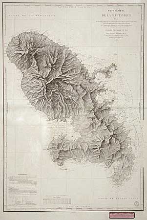
Subject: Martinique

Period: 1831 (dated)

Publication: Atlas de la Martinique

Color: Black & White

Size:
35.5 x 24 inches
90.2 x 61 cm
Download High Resolution Image
(or just click on image to launch the Zoom viewer)

Large, handsome chart by P. Monnier. This is a very fine example of the workmanship of the French Hydrographic office. The mountainous terrain is depicted so well that it almost appears to be a relief map. The approaches to the island are well delineated with soundings, anchorages and hazards all marked. The three lighthouses are colored in yellow and red, else uncolored. This chart was issued for use aboard ship and is thus printed on fine sturdy paper. Paper advertisement label of the chart seller in lower margin.

References: Phillips (A) #2718-2.

Condition: A

Generally very good with very faint and unobtrusive offsetting with some acid burn to verso.

Estimate: $300 - $350

Sold for: $230

Closed on 9/12/2001

Archived