Catalog Archive
Auction 95, Lot 418

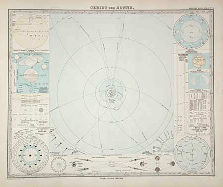
"Adolf Stieler's Hand Atlas uber Alle Theile der Erde und uber das Weltgebaude 95 Karten", Perthes, Justus

Subject: Atlas

Period: 1879 (dated)

Publication:

Color: Hand Color

Size:
20 x 15.8 inches
50.8 x 40.1 cm
Download High Resolution Image
(or just click on image to launch the Zoom viewer)

Complete tall folio atlas with 84 full-page maps. Each map is a study in precision engraving, with exceptional detail and fine outline coloring. Also bound at back are an additional eight map sheets that if joined would make a large map titled "Karte Des Mittellandischen Meeres in 8 Blattern." The map is dated 1880 and covers the Mediterranean region from Portugal to the Caspian Sea in the north and in the south from Morocco to Persia. Front cover detached with leather crumbling. Most leather at spine is gone. Marbled endpapers.

References:

Condition: B

All maps are very good to fine condition. Front cover detached with leather crumbling. Most leather at spine is gone . Marbled endpapers.

Estimate: $400 - $500

Sold for: $350

Closed on 6/13/2001

Archived