Subject: Virginia
Period: 1861 (dated)
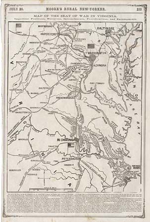
Publication: Moore's Rural New-Yorker
Color: Black & White
Size:
12.8 x 19.4 inches
32.5 x 49.3 cm
This simple woodcut map, published during the Manassas Campaign, depicts strategic cities and towns, transportation routes, fortified positions, and the location and number of Confederate troops at several locations. It is typical of the maps that appeared throughout the CIVIL WAR in newspapers and weekly journals. Below the map is an article discussing the war stating that "…readers can trace the movements of such as are endeavoring to degrade and disgrace their county, and also of those who are gallantly battling for Right. Liberty, and Law".
References:
Condition: B
Couple of minor spots and a damp stain at top.