Catalog Archive
Auction 93, Lot 93

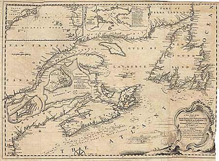
"A New Chart of the Coast of New England, Nova Scotia, New France or Canada, with the Islands of Newfoundld. Cape Breton St. John's &c…", Jefferys, T.
Subject: Colonial United States and Canada

Period: 1746 (published)

Publication: Gentleman's Magazine

Color: Black & White

Size:
18.5 x 13.5 inches
47 x 34.3 cm
Download High Resolution Image
(or just click on image to launch the Zoom viewer)

Copper engraved map based on Bellin's important map of the region done in 1744. The map includes New England as far south as Boston, the St. Lawrence River just beyond Quebec, and as far north as Cape Round. The map includes only coastal detail complete with soundings and the fishing banks. There are an array of nice insets including a large map of the Atlantic Ocean showing the American coastline to South Carolina. Also insets of "Plan of the City and Port of Louisbourg", "Fort Dauphin", and "City of Quebec". The large decorative title cartouche includes a nice landscape view. Trimmed inside border on binding side and into neatline at top and right.

References: Kershaw #692, Jolly Bent-40.

Condition: C

Trimmed inside border on binding side and into neatline at top and right.

Estimate: $250 - $280

Sold for: $170

Closed on 12/6/2000

Archived