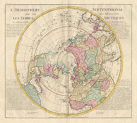
Subject: Northern Hemisphere
Period: 1750 (circa)
Publication: Nieuwe Atlas
Color: Hand Color
Size:
20 x 18 inches
50.8 x 45.7 cm
A large handsome map depicting from the pole to the Equator with good detail, and showing all the political divisions. The map was originally made by the French cartographer Guillaume De l'Isle in 1714 with his characteristic scientific approach. This is the updated issue by Covens and Mortier. The Northwest coast of North America now includes the 1741 discoveries of Bering and Tschirikow, and shows the emerging shape of Alaska. The "R. de l'Ouest" connects the Pacific with Lake Winnipeg and through a series of rivers and lakes with Hudson Bay. Text panels flanking the map include a letter (printed in French and Dutch), dated Jan. 13, 1740, by a Dutch nobleman residing in St. Petersburg, relating to the recent exploring expedition to Japan, commanded by Lt. Morten Spanberg, a Dane in the Russian navy.
References:
Condition: A+
Fine original color.