Subject: Washington
Period: 1862 (dated)
Publication: HR ex doc 1 37th Congress. 3rd Ses..
Color: Black & White
Size:
35 x 17 inches
88.9 x 43.2 cm
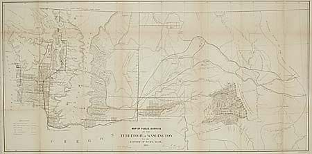
On May 2, 1853, Congress established the Washington Territory. At that time most of the population was living west of the Cascades. As can been seen from the map, not much progress had been made in the Public Surveys. By 1862, a westward movement to the Idaho etc. mines had given impetus to the separation of the Idaho, - Montana area and in March 1863 the Idaho Territory was created. Thus, in this map we see Washington T. just before the separation. The map shows Indian Reservations and land claims of the Puget Sound Agricultural Company. Proposed railroad routes, hydrographic and mountain topography are also shown.
References:
Condition: B
Professionally backed with archival tissue. Light toning along some fold lines.