Catalog Archive
Auction 93, Lot 108

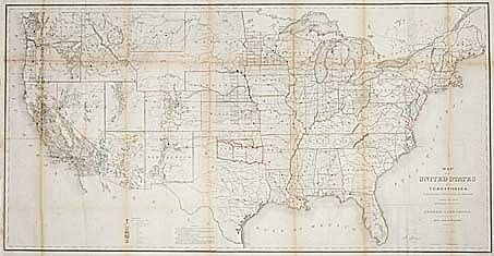
"Map of the United States and Territories Showing the extent of Public Surveys and other details constructed from the Plats and official sources of the General Land Office…", General Land Office
Subject: United States

Period: 1866 (dated)

Publication:

Color: Hand Color

Size:
54.5 x 28 inches
138.4 x 71.1 cm
Download High Resolution Image
(or just click on image to launch the Zoom viewer)

A large and handsome map of the U.S. that is filled with information. The two northern railroads are shown as proposed. A legend color codes the locations of gold, silver, copper, quicksilver, iron, tin, asphaltum and oil springs. Dakota jogs down and south to include the unnamed region of Wyoming. Much progress in public surveys remains to be done in the western areas. Geographical and hydrological details are considerably and very legible.

References: Wheat [TMW] 1168.

Condition: B

Backed with Japanese tissue, toned along folds. Surprisingly good condition for its size.

Estimate: $400 - $500

Sold for: $300

Closed on 12/6/2000

Archived