Subject: Colonial United States and Canada
Period: 1664 (circa)
Publication:
Color: Black & White
Size:
20.5 x 13.5 inches
52.1 x 34.3 cm
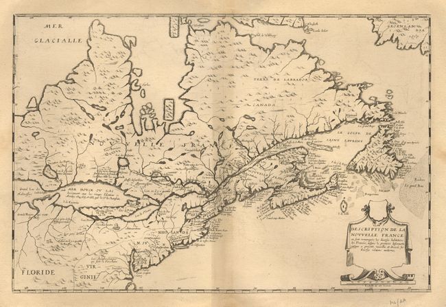
Rare and important GREAT LAKES map first issued in 1643. According to Burden it is actually the first printed map to show and name all five lakes, pre-dating the Sanson map of 1650. The map is based on Champlain's map of 1632 improved to incorporate names. Although the configuration and size of the lakes are incorrect, the map is of seminal importance to the cartography of the region. "Lac St. Louis" (Lake Ontario) leads into "Lac Derie" (Lake Erie) which is shown very small because Champlain, relying on second-hand knowledge, greatly underestimated its size. "Mer Douce ou Lac" (Lake Huron) and "Grand Lac" (Lake Superior) are much more recognizable. Lake Michigan is again confused and represented either by a small lake to the northeast named "Lac des Puans" (the same name used by Sanson) or an inlet in the south of Lake Superior called "Grande Riviere qui vient du midy". This is the second state of the map with additional names and the delineation of "Virginie", "N. Svede", "N. Hollande", and "N. Angleterre".
References: Burden #261; Kershaw #84; Verner & Stuart-Stubbs #5.
Condition: A+
Very wide margins with very minor browning, overall fine with a crisp impression.