Subject: Colonial United States and Canada
Period: 1625 (published)
Publication: Purchas his Pilgrimes
Color: Black & White
Size:
13.4 x 9.7 inches
34 x 24.6 cm
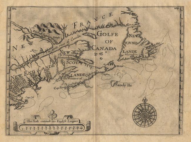
A cartographically significant map designating "New Scotlande" and naming "Cape Cod" for the first time on a printed map. The New England Company, incorporated in 1620, was reorganized in 1623 and patents were granted to twenty investors, whose names appear for the first time on this map. Alexander was responsible for the lands to the east and north of the St. Croix River which he named "New Scotlande" (Nova Scotia). He also introduced several other Scottish names including the renaming of the St. Croix River as the "Clyde River" because it separated New England from New Scotland. Despite his efforts, the colony failed to flourish and the region was ceded to the French in 1632. Alexander used several sources of information in compiling his map, including Champlain (1612-13), De Laet, and Mason. Other important "cartographic firsts" include the location and extent of Placentia Bay, the Avalon Peninsula appears in rudimentary form, and an island appears in the position of Prince Edward Island (although it is not named). The map was included in Alexander's "An Encouragement to Colonies" in 1624 and was republished in Samuel Purchas' "Pilgrims" in 1625. Second state. $6,000 RESERVE.
References: Burden #208; Kershaw #86; Schwartz & Ehrenberg, plt. 54.
Condition: A
A very crisp impression. Has been backed with fine linen strengthening some marginal weakness, probably in the 19th century.