Catalog Archive
Auction 91, Lot 84

"Partie de la carte du Captaine Cluny auteur d'une ouvrage Anglois Intitute American Traveller publie a London en 1769",

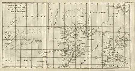
Subject: North America

Period: 1777 (published)

Publication: Diderot's Encyclopedia

Color: Black & White

Size:
19 x 11.2 inches
48.3 x 28.4 cm
Download High Resolution Image
(or just click on image to launch the Zoom viewer)

Depicts North America from above the Arctic Circle, to the Gulf of Mexico. The most important feature of the map is the early depiction of what is present day Alaska, and is patterned after Muller's epic map of 1750 which was the first to show the Russian discoveries, also noted here. A very interesting Northwest Passage is shown going from Repulse Bay in the north part of Hudson's Bay over into the Arctic Ocean at a place called Cape Fowler. Good detail of Baffins Bay and Hudson Bay. Ref: Wagner (NW) #637, Pedley #460. Minor ink offsetting that can easily be erased. Very crisp impression.

References:

Condition: A

Estimate: $200 - $250

Sold for: $210

Closed on 6/14/2000

Archived