Subject: Africa
Period: 1737 (circa)
Publication:
Color: Hand Color
Size:
18.2 x 22 inches
46.2 x 55.9 cm
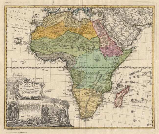
Double page copperplate engraving with full original outline and body color. Homann's signature decorative cartouche (uncolored) features Europeans negotiating with an African prince. Exotic flora and fauna including lions, a jaguar, elephants, a rhinoceros, a crocodile, tropical birds and unidentifiable reptiles complete the composition. This beautiful 18th century map of Africa shows Homann's c. 1715 map, augmented by Johann Matthias Haas to include important cartographic developments to the continent after Guillaume De l'Isle and D'Anville. As is typical for maps of the 18th century. Homann focuses on the known coastal regions of the continent, leaving the interiors parts blank or marked 'Terra Incognito'. Africa is divided into 13 regions and Madagascar; the earlier Homann map had only separated the continent into six regions and the island. The Nile is reduced from its Ptolemaic southern reaches (and fictitious sources), Egypt, Nubia and Abyssinia are shown as distinct entities, Lake Nyasa is shown as 'Lac Marawi' and the Congo located. However, anomalies and misconceptions abound, waiting for the 19th century forays to the African interior for correction. The map follows the traditional multi-cultural nomenclature for the continent, most of which is still in use today. The lands south of Egypt were called 'Aetheopia' by the ancient Greeks. 'Balad as Sudan' by Arabs, and 'Negritia' by medieval Latin writers. All these terms mean 'Land of the Blacks'. But according to standard 18th century usage, this map uses these terms as though they were placenames. Ref: Norwich #83. Fine impression and condition.
References:
Condition: A+