Subject: Colonial Canada and United States
Period: 1677 (dated)
Publication: Cartes de Geographiques
Color: Hand Color
Size:
21.5 x 13.7 inches
54.6 x 34.8 cm
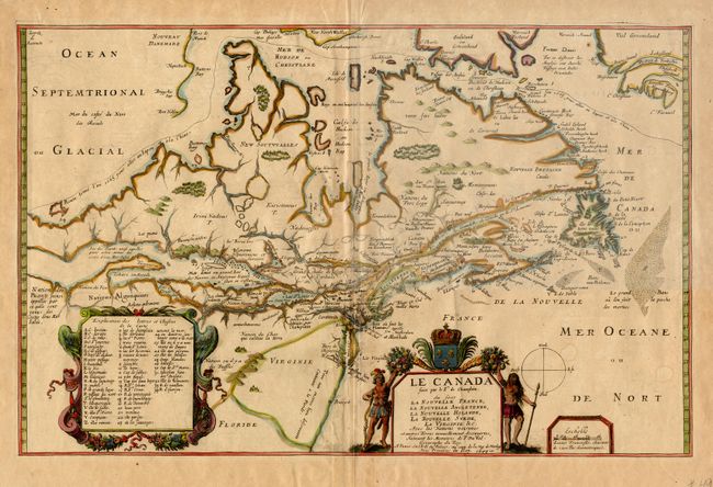
This is the final state of Champlain's 1616 map of northeastern North America. Champlain himself never issued the map (except in a single extant proof copy), and it was not until Du Val acquired the plate in the early 1650's that the map appeared in print . Du Val added numerous placenames and cartouches. The map depicts the existence of a Great Lakes network, based on Indian accounts and Champlain's travels in the region. Three lakes, Lac St. Louis, Mer douce ou gande Lac des Hurons, and Lac des Tuanst appear in a very rudimentary form. There is a notation alluding to a possible link to a western sea and the waterway is open-ended at the map's western border. In addition, a possible NORTHWEST PASSAGE is shown through Buttons Bay with an Arctic route "Route tenue l'an 1665 pour aller au Iapon et a la Chine" winding its way through Hudson Strait and Buttons Bay. British colonies are shown in both New England and Virginia, divided by the Dutch colony of New Holland. This is the final state of the map, with Du Val's address at "au coin de la rue de Harlay", and the addition of elaborate surrounds for the cartouches. All states of the map are rare. Ref: Burden #309; Kershaw #79; and Verner & Stubbs #7. A fine impression with old color. Old repairs of fold in margins, still very fine. $9,000 RESERVE
References:
Condition: A+