Subject: Western Hemisphere
Period: 1763 (dated)
Publication:
Color: Hand Color
Size:
24 x 19 inches
61 x 48.3 cm
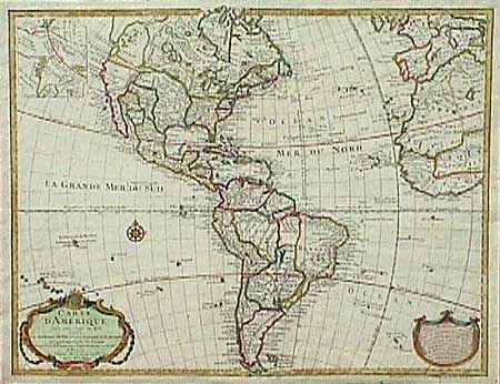
First issued by De l'Isle in 1722 and one of the most popular maps of the 18th Century. This is the seventh state, altered to include his successor's theories in the Northwest. There is a large 'Mer de Ouest' and an inset in the upper left corner shows an entirely hypothetical continuation of the northwest coast with a 'Lac de Valasco'. The political divisions are shown in colored outline and the garland style title cartouche and advertisement cartouche are fully colored. Ref: Tooley (America) #7, p. 14. Some light creasing, else very good and bright.
References:
Condition: A